
File:Developmental-Plan-Banks.jpg
Original file (1,029 × 1,200 pixels, file size: 190 KB, MIME type: image/jpeg)
| This is a file from the Wikimedia Commons. Information from its description page there is shown below. Commons is a freely licensed media file repository. You can help. |
Summary
| Description |
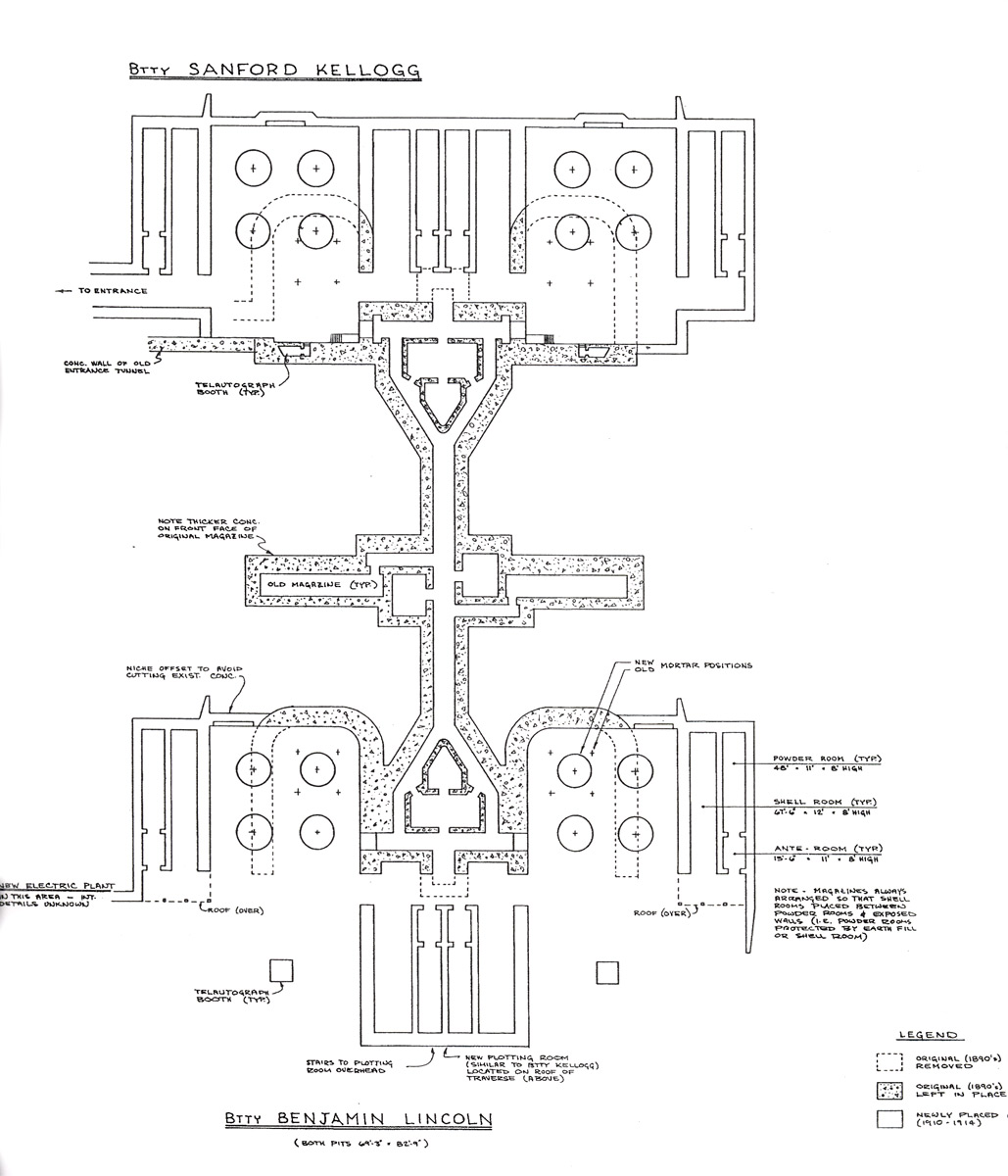
English: This is a portion of the plan view of the two coast defense mortar batteries at Fort Banks, Winthrop, MA. Originally researched and drawn by Thomas Vaughan of the Coast Defense Study Group (and updated through December, 1982), the plan is a portion of a larger diagram that also includes elevations of the exterior of the mortar pits. The plan was drawn by Vaughan based on original plans of the batteries drawn up by the U.S. Army Engineers during the period 1891-1896 and upon piecing together notes at the National Archives for the period 1910-1917. The diagram must have involved hundreds of hours of research and drafting.
This portion of the plan is abstracted from a public document dated February, 2001, being the submission by Mr. Vaughan and the Fort Banks Preservation Association to the Massachusetts Historical Commission requesting designation of the site of the batteries as part of the National Register of Historic Places. The designation was granted by the U.S. government. This plan charts the outlines of the four mortar pits, three of which are still (in 2010) visible from the surface, and also details the subterranean structure of the batteries' magazines and connecting galleries, all of which are now buried, and only some of which remain accessible. The central corridor illustrated runs almost directly east-west, with east at the top of this diagram. The two mortar pits on the left (north) side of this plan were called the "B" pits of each battery, and the ones on the right (south) side the "A" pits. Btty Kellogg Pit B is the one that has mostly been excavated and can be entered today through a gate opening on the Winthrop Dept. of Public Works parking lot (or by descending a filled-in ramp from the street that was constructed when the pit was recently excavated). Kellogg Pit A is now completely obscured by an apartment building that covers it, while both pits of Btty Lincoln have been partially filled, paved over, and are today used for parking. The plan clearly shows how the original pits, which proved to be too cramped for the service of four mortars at once, were enlarged over time. According to Vaughan, no other coast defense mortar battery in the country has this unique magazine design or apparent evidence of redesign and reconstruction of all its four pits. |
| Source | This portion of the plan is abstracted from a public document dated February, 2001, being the submission by Mr. Vaughan and the Fort Banks Preservation Association to the Massachusetts Historical Commission requesting designation of the site of the batteries as part of the National Register of Historic Places. The designation was granted by the U.S. government. |
| Author |
Licensing
This work is in the public domain in the United States because it is a work prepared by an officer or employee of the United States Government as part of that person’s official duties under the terms of Title 17, Chapter 1, Section 105 of the US Code.
Note: This only applies to original works of the Federal Government and not to the work of any individual U.S. state, territory, commonwealth, county, municipality, or any other subdivision. This template also does not apply to postage stamp designs published by the United States Postal Service since 1978. (See § 313.6(C)(1) of Compendium of U.S. Copyright Office Practices). It also does not apply to certain US coins; see The US Mint Terms of Use.
|
 | |
| This file has been identified as being free of known restrictions under copyright law, including all related and neighboring rights. | ||
File history
Click on a date/time to view the file as it appeared at that time.
| Date/Time | Thumbnail | Dimensions | User | Comment | |
|---|---|---|---|---|---|
| current | 15:38, 20 August 2010 | | 1,029 × 1,200 (190 KB) | Pgrig | This is a portion of the plan view of the two coast defense mortar batteries at Fort Banks, Winthrop, MA. Originally researched and drawn by Thomas Vaughan of the Coast Defense Study Group (and updated through December, 1982), the plan is a portion of a l |