
File:Distancia a la costa.png
Size of this preview: 800 × 387 pixels. Other resolutions: 320 × 155 pixels | 640 × 310 pixels | 1,278 × 619 pixels.
Original file (1,278 × 619 pixels, file size: 304 KB, MIME type: image/png)
| This is a file from the Wikimedia Commons. Information from its description page there is shown below. Commons is a freely licensed media file repository. You can help. |
Summary
| Description |
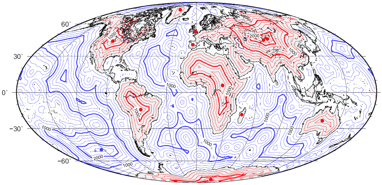
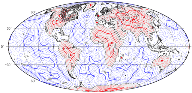
Español: Mapa global de distancia a la línea de costa.
English: Map of great-circle distance to the coastline. |
| Date | |
| Source | self-made using the technique described in Garcia-Castellanos, D., & U. Lombardo, 2007. Poles of Inaccessibility: a calculation algorithm for the remotest places on Earth. Scott. Geogr. J., 123, 227-233. Based on the coastline database of Wessel, P. & Smith, W. H. F. (1996) A global self-consistent, hierarchical, high-resolution shoreline database, Journal of Geophysical Research, 101, B4, 8741 – 8743. Lake shores are excluded. |
| Author | Gaianauta |

|
This map image could be re-created using vector graphics as an SVG file. This has several advantages; see Commons:Media for cleanup for more information. If an SVG form of this image is available, please upload it and afterwards replace this template with
{{vector version available|new image name}}.
It is recommended to name the SVG file “Distancia a la costa.svg”—then the template Vector version available (or Vva) does not need the new image name parameter. |

|
This image is an information graphic created by a computer program from data sets or formulas that have not been fully provided on this page. In order to allow other editors to improve or build such images, and to ensure compliance with free content licenses such as the GFDL, the following should be provided:
|
|
| |
Licensing
I, the copyright holder of this work, hereby publish it under the following licenses:

|
Permission is granted to copy, distribute and/or modify this document under the terms of the GNU Free Documentation License, Version 1.2 or any later version published by the Free Software Foundation; with no Invariant Sections, no Front-Cover Texts, and no Back-Cover Texts. A copy of the license is included in the section entitled GNU Free Documentation License. |
This file is licensed under the Creative Commons Attribution-Share Alike 4.0 International, 3.0 Unported, 2.5 Generic, 2.0 Generic and 1.0 Generic license.
- You are free:
- to share – to copy, distribute and transmit the work
- to remix – to adapt the work
- Under the following conditions:
- attribution – You must give appropriate credit, provide a link to the license, and indicate if changes were made. You may do so in any reasonable manner, but not in any way that suggests the licensor endorses you or your use.
- share alike – If you remix, transform, or build upon the material, you must distribute your contributions under the same or compatible license as the original.
You may select the license of your choice.
File history
Click on a date/time to view the file as it appeared at that time.
| Date/Time | Thumbnail | Dimensions | User | Comment | |
|---|---|---|---|---|---|
| current | 10:17, 24 March 2015 | | 1,278 × 619 (304 KB) | RokerHRO | optipng -o7 -i0 → 41.44% decrease |
| 15:02, 2 December 2010 |  | 1,278 × 619 (519 KB) | Beao | Transparent. | |
| 22:52, 25 July 2008 |  | 1,278 × 619 (504 KB) | Timwi | ||
| 18:43, 29 January 2008 |  | 1,278 × 619 (353 KB) | Gaianauta | {{Information |Description=Mapa global de distancia a la línea de costa |Source=self-made |Date=2008 |Author= Gaianauta |Permission= |other_versions= }} |
File usage
The following pages on the English Wikipedia use this file (pages on other projects are not listed):
Global file usage
The following other wikis use this file:
- Usage on ast.wikipedia.org
- Usage on ca.wikipedia.org
- Usage on cs.wikipedia.org
- Usage on da.wikipedia.org
- Usage on de.wikipedia.org
- Usage on eo.wikipedia.org
- Usage on es.wikipedia.org
- Usage on fa.wikipedia.org
- Usage on fi.wikipedia.org
- Usage on fr.wikipedia.org
- Usage on id.wikipedia.org
- Usage on it.wikipedia.org
- Usage on ja.wikipedia.org
- Usage on ko.wikipedia.org
- Usage on lb.wikipedia.org
- Usage on lt.wikipedia.org
- Usage on nn.wikipedia.org
- Usage on no.wikipedia.org
- Usage on pt.wikipedia.org
- Usage on ro.wikipedia.org
- Usage on ru.wikipedia.org
- Usage on sk.wikipedia.org
- Usage on tr.wikipedia.org
- Usage on uk.wikipedia.org
- Usage on vi.wikipedia.org
- Usage on www.wikidata.org
- Usage on zh.wikipedia.org