
File:East-tennessee-landforms.png
No higher resolution available.
East-tennessee-landforms.png (434 × 264 pixels, file size: 238 KB, MIME type: image/png)
| This is a file from the Wikimedia Commons. Information from its description page there is shown below. Commons is a freely licensed media file repository. You can help. |
Summary
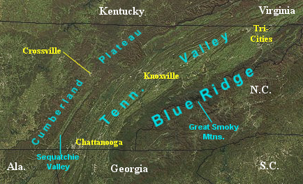
| Description | Satellite image showing the major topographical features of East Tennessee. |
| Date | (image); 2009-08 (annotation) |
| Source | [http://rapidfire.sci.gsfc.nasa.gov/gallery/ NASA MODIS Rapid Response System |
| Author | NASA (image); Brian Stansberry (annotation) |
Licensing
| This file is in the public domain in the United States because it was solely created by NASA. NASA copyright policy states that "NASA material is not protected by copyright unless noted". (See Template:PD-USGov, NASA copyright policy page or JPL Image Use Policy.) | ||
 |
Warnings:
|
File history
Click on a date/time to view the file as it appeared at that time.
| Date/Time | Thumbnail | Dimensions | User | Comment | |
|---|---|---|---|---|---|
| current | 21:57, 18 August 2009 | | 434 × 264 (238 KB) | BrineStans | {{Information |Description=Satellite image showing the major topographical features of East Tennessee. |Source=[http://rapidfire.sci.gsfc.nasa.gov/gallery/ NASA MODIS Rapid Response System |Date=2004-12 (image); 2009-08 (annotation) |Author=NASA (image) |
File usage
The following pages on the English Wikipedia use this file (pages on other projects are not listed):
Global file usage
The following other wikis use this file:
- Usage on zh.wikipedia.org