
File:East Aberthaw lagoon - geograph.org.uk - 848197.jpg
No higher resolution available.
East_Aberthaw_lagoon_-_geograph.org.uk_-_848197.jpg (640 × 467 pixels, file size: 85 KB, MIME type: image/jpeg)
| This is a file from the Wikimedia Commons. Information from its description page there is shown below. Commons is a freely licensed media file repository. You can help. |
Summary
| Description |
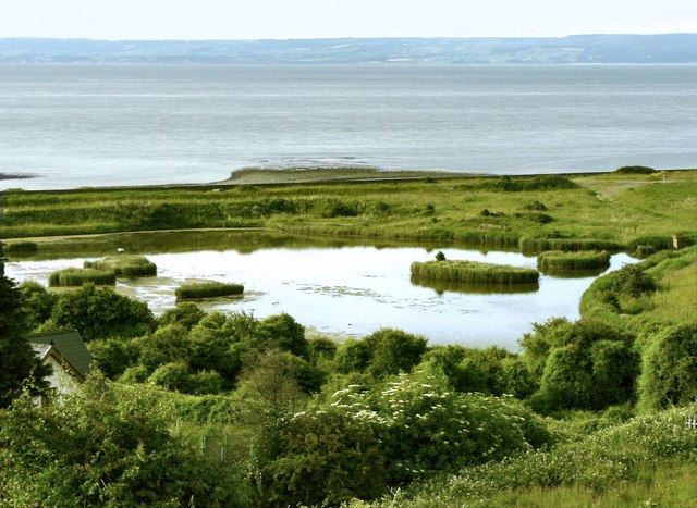
English: East Aberthaw lagoon This area, at the estuary of the River Thaw was once a busy port. The landscape was substantially altered by the building of Aberthaw Power Station when the river was straightened and the estuary became a tidal lagoon. Much of the nearby area is covered by ash from the station but it remains a site of importance for wild life. Since the tip was extended in the late '80s the reed beds have begun to regenerate and are now used by both Reed and Sedge Warblers. An Aquatic Warbler was trapped and ringed here, also in the '80s, and the reed beds served as roosts for Whinchat, Reed and Sedge Warbler, Kingfisher, Swallow and Yellow Wagtails and it is to be hoped that they, as well as other species that once used the area, might well be seen again as the area develops further. |
| Date | |
| Source | From geograph.org.uk |
| Author | Mick Lobb |
| Attribution (required by the license) | Mick Lobb / East Aberthaw lagoon / |
| Camera location | | View this and other nearby images on: OpenStreetMap |
|---|
_heading:225.00&language=en)
| Object location | | View this and other nearby images on: OpenStreetMap |
|---|
_heading:225.00&language=en)
Licensing

|
This image was taken from the Geograph project collection. See this photograph's page on the Geograph website for the photographer's contact details. The copyright on this image is owned by Mick Lobb and is licensed for reuse under the Creative Commons Attribution-ShareAlike 2.0 license.
|
This file is licensed under the Creative Commons Attribution-Share Alike 2.0 Generic license.
Attribution: Mick Lobb
- You are free:
- to share – to copy, distribute and transmit the work
- to remix – to adapt the work
- Under the following conditions:
- attribution – You must give appropriate credit, provide a link to the license, and indicate if changes were made. You may do so in any reasonable manner, but not in any way that suggests the licensor endorses you or your use.
- share alike – If you remix, transform, or build upon the material, you must distribute your contributions under the same or compatible license as the original.
File history
Click on a date/time to view the file as it appeared at that time.
| Date/Time | Thumbnail | Dimensions | User | Comment | |
|---|---|---|---|---|---|
| current | 22:44, 20 February 2011 | | 640 × 467 (85 KB) | GeographBot | == {{int:filedesc}} == {{Information |description={{en|1=East Aberthaw lagoon This area, at the estuary of the River Thaw was once a busy port. The landscape was substantially altered by the building of Aberthaw Power Station when the river was straighten |
File usage
The following pages on the English Wikipedia use this file (pages on other projects are not listed):
Global file usage
The following other wikis use this file:
- Usage on www.wikidata.org