
File:Electrified main lines in CZ.svg

Size of this PNG preview of this SVG file: 800 × 446 pixels. Other resolutions: 320 × 178 pixels | 640 × 357 pixels | 1,024 × 571 pixels | 1,280 × 713 pixels | 2,560 × 1,427 pixels | 1,141 × 636 pixels.
Original file (SVG file, nominally 1,141 × 636 pixels, file size: 796 KB)
| This is a file from the Wikimedia Commons. Information from its description page there is shown below. Commons is a freely licensed media file repository. You can help. |
Summary
| Description |
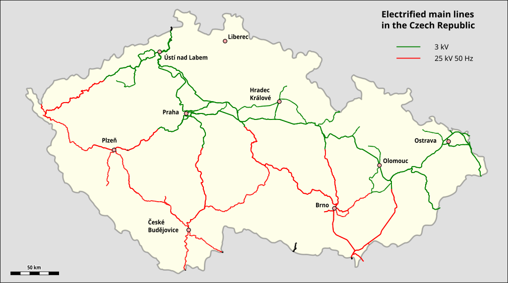
English: Map of electrified main lines in the Czech Republic |
| Date | |
| Source | Map created by using Open Street Map Data |
| Author |
|
| Other versions | German title |
Licensing
| This work is licensed under the Open Database License (summary). |
File history
Click on a date/time to view the file as it appeared at that time.
| Date/Time | Thumbnail | Dimensions | User | Comment | |
|---|---|---|---|---|---|
| current | 19:31, 20 January 2023 | | 1,141 × 636 (796 KB) | Pechristener | colored points |
| 18:10, 19 January 2023 |  | 1,141 × 636 (796 KB) | Pechristener | {{Information |description={{en|1=Map of electrified main lines in the Czech Republic}} |date=2023-01-19 |source=Map created by using [http://www.openstreetmap.org/ Open Street Map Data] |author= * data: OpenStreetMap contributors * rendering: {{u|Pechristener}} |permission= |other versions={{f|Electrified main lines in CZ de.svg|German title}} }} =={{int:license-header}}== {{ODbL}} Category:Map of Czech railways.svg |
File usage
The following pages on the English Wikipedia use this file (pages on other projects are not listed):
Global file usage
The following other wikis use this file:
- Usage on simple.wikipedia.org