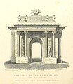
File:Entrance to the King's Palace, Hyde Park Corner - Shepherd, Metropolitan Improvements (1828), p326.jpg

Page contents not supported in other languages.
This is a file from the Wikimedia Commons
From Wikipedia, the free encyclopedia

Original file(1,266 × 1,464 pixels, file size: 449 KB, MIME type: image/jpeg)

Summary

Artist
Thomas Hosmer Shepherd  (–1864)  wikidata:Q2424467
 
Alternative names
Birth name: Thomas Hosmer Shepherd; Thomas H. Shepherd; Thomas Shepherd; Shepherd; T. Hosmer Shepherd; T. H. Shepherd
Description British aquarellist
Date of birth/death 1792 / 1793 Edit this at Wikidata 4 July 1864 Edit this at Wikidata
Location of birth/death Islington
Work location
London (1813–1851) Edit this at Wikidata
Authority file
artist QS:P170,Q2424467
Description
English: The originally intended design for the Wellington Arch at Hyde Park Corner by Decimus Burton, built from 1826–30 and so still under construction when the print was published. The engraving shows the full set of sculptures first intended to decorate the arch, including reliefs on the arch itself and statues of warriors above and between the columns. To save costs these were all ultimately omitted, to compensate for the overspending incurred in the refurbishment of Buckingham Palace being undertaken at the same time. A notable loss was the statue of the quadriga intended to top the monument, a Roman four-horse chariot similar to the statues on the top of the Brandenburg Gate in Berlin (1793) or the Arc de Triomphe du Carrousel in Paris (1806-08). Instead the space was eventually taken by a three times lifesize bronze equestrian statue of the Duke of Wellington, which stood there from 1846 to 1882. The present bronze statue by Adrian Jones of the Angel of Peace descending onto a quadriga was added in 1912.

The arch was originally placed facing north-north-east directly opposite Burton's Ionic Screen entrance to Hyde Park (1824–25), as the entrance to a grand processional route to Buckingham Palace along Constitution Hill (the end of which was re-aligned to run adjacent to Grosvenor Place to approach the arch squarely). A road-widening scheme at Hyde Park Corner in 1882–83 required the arch to be moved east, losing its relationship to the Hyde Park screen, although it still stood at the head of Constitution Hill, with which it was now placed on axis, facing westwards. The road junction was again remodelled in 1961–62 with the opening of the Park Lane dual carriageway, creating the present large roundabout and Hyde Park Corner underpass, so that the arch now sits in the middle of a large traffic island, although the route through it to Constitution Hill is still sometimes used for ceremonial purposes.

Date 7 July 1827
date QS:P571,+1827-07-07T00:00:00Z/11
Accession number
British Library HMNTS 010349.s.3
Source/Photographer

Image extracted from page 326 of Metropolitan Improvements; or London in the Nineteenth Century, by James Elmes. Original held and digitised by the British Library. Copied from Flickr.

Note: The colours, contrast and appearance of these illustrations are unlikely to be true to life. They are derived from scanned images that have been enhanced for machine interpretation and have been altered from their originals.

This file is from the Mechanical Curator collection, a set of over 1 million images scanned from out-of-copyright books and released to Flickr Commons by the British Library.

 View image on Flickr   View all images from book 

 View catalogue entry for book

العربية‎ | беларуская (тарашкевіца)‎ | English | français | galego | македонски | suomi | +/−

Permission
(Reusing this file)
Public domain

This work is in the public domain in its country of origin and other countries and areas where the copyright term is the author's life plus 70 years or fewer.


This work is in the public domain in the United States because it was published (or registered with the U.S. Copyright Office) before January 1, 1929.


Camera location51° 30′ 11.36″ N, 0° 09′ 08.23″ W  Heading=157.5° Kartographer map based on OpenStreetMap.View this and other nearby images on: OpenStreetMapinfo

Licensing

This image was taken from Flickr's The Commons. The uploading organization may have various reasons for determining that no known copyright restrictions exist, such as:
  1. The copyright is in the public domain because it has expired;
  2. The copyright was injected into the public domain for other reasons, such as failure to adhere to required formalities or conditions;
  3. The institution owns the copyright but is not interested in exercising control; or
  4. The institution has legal rights sufficient to authorize others to use the work without restrictions.

More information can be found at https://flickr.com/commons/usage/.


Please add additional copyright tags to this image if more specific information about copyright status can be determined. See Commons:Licensing for more information.
This image was originally posted to Flickr by The British Library at https://www.flickr.com/photos/12403504@N02/11008085493. It was reviewed on 2014-04-12 22:51:55 by FlickreviewR, who found it to be licensed under the terms of the No known copyright restrictions, which is compatible with the Commons. It is, however, not the same license as given above, and it is unknown whether that license ever was valid.

Captions

Add a one-line explanation of what this file represents

Items portrayed in this file

depicts

51°30'11.362"N, 0°9'8.230"W

heading: 157.5 degree

File history

Click on a date/time to view the file as it appeared at that time.

Date/TimeThumbnailDimensionsUserComment
current17:04, 19 July 2016Thumbnail for version as of 17:04, 19 July 20161,266 × 1,464 (449 KB)HohumCropped, straightened
23:16, 12 April 2014Thumbnail for version as of 23:16, 12 April 20141,424 × 1,527 (498 KB)RotatebotBot: Image rotated by 90°
21:59, 12 April 2014Thumbnail for version as of 21:59, 12 April 20141,527 × 1,428 (500 KB)JhealdTransferred from Flickr via Flickr2commons
The following pages on the English Wikipedia use this file (pages on other projects are not listed):

Global file usage

The following other wikis use this file: