
File:EtoshaPan 2005-06 comparison.jpg

Size of this preview: 414 × 600 pixels. Other resolutions: 166 × 240 pixels | 540 × 782 pixels.
Original file (540 × 782 pixels, file size: 103 KB, MIME type: image/jpeg)
| This is a file from the Wikimedia Commons. Information from its description page there is shown below. Commons is a freely licensed media file repository. You can help. |
Summary
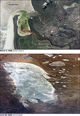
| Description | Two images of the w:Etosha pan in Namibia. The upper view (March 2006) shows the point where the Ekuma River flows into the salt lake; the lower regional image (June 2005) shows the same inlet—but dry—on the north shore of Etosha Pan. Both photos taken from the International Space Station. |
| Date | |
| Source | http://earthobservatory.nasa.gov/Newsroom/NewImages/images.php3?img_id=17261 |
| Author | ISS Crew Earth Observations experiment and the Image Science & Analysis Group, Johnson Space Center. Images cropped, cleaned up, and labelled by NASA Earth Observatory. |
| Permission (Reusing this file) |
US government, public domain |
| Other versions | Links to original images available at source URL. |
.jpg)
Licensing
| This file is in the public domain in the United States because it was solely created by NASA. NASA copyright policy states that "NASA material is not protected by copyright unless noted". (See Template:PD-USGov, NASA copyright policy page or JPL Image Use Policy.) | ||
 |
Warnings:
|
File history
Click on a date/time to view the file as it appeared at that time.
| Date/Time | Thumbnail | Dimensions | User | Comment | |
|---|---|---|---|---|---|
| current | 16:07, 1 May 2006 | | 540 × 782 (103 KB) | Holly Cheng | {{Information | Description=Two images of the w:Etosha pan in Namibia. The upper view (March 2006) shows the point where the Ekuma River flows into the salt lake; the lower regional image (June 2005) shows the same inlet—but dry—on the north shore |
File usage
The following pages on the English Wikipedia use this file (pages on other projects are not listed):
Global file usage
The following other wikis use this file:
- Usage on af.wikipedia.org
- Usage on bg.wikipedia.org
- Usage on ca.wikipedia.org
- Usage on ceb.wikipedia.org
- Usage on eo.wikipedia.org
- Usage on es.wikipedia.org
- Usage on fa.wikipedia.org
- Usage on fr.wikipedia.org
- Usage on lb.wikipedia.org
- Usage on pl.wikipedia.org
- Usage on sk.wikipedia.org
- Usage on sl.wikipedia.org
- Usage on www.wikidata.org
- Usage on zh.wikipedia.org