
File:Extract from Report to the Minister of War Transport 21 January 1946 Map 3 - Charing Cross Area.jpg
No higher resolution available.
Extract_from_Report_to_the_Minister_of_War_Transport_21_January_1946_Map_3_-_Charing_Cross_Area.jpg (558 × 338 pixels, file size: 172 KB, MIME type: image/jpeg)
| This is a file from the Wikimedia Commons. Information from its description page there is shown below. Commons is a freely licensed media file repository. You can help. |
Summary
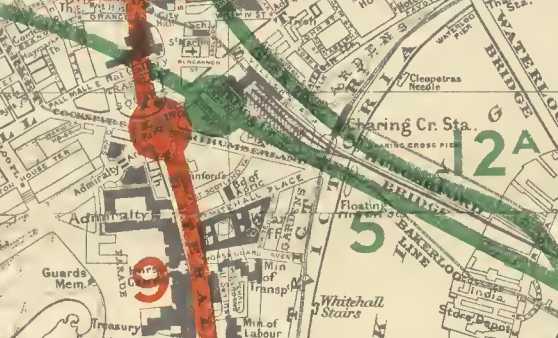
| Description | Extract from Map 3 from report, showing proposed new rail routes in Charing Cross area |
| Date | |
| Source | Report to the Minister of War Transport, 21 January 1946 |
| Author | Railway (London Plan) Committee 1944 - Chairman Charles Inglis |
| Other versions |
|
This work created by the United Kingdom Government is in the public domain.
This is because it is one of the following:
HMSO has declared that the expiry of Crown Copyrights applies worldwide (ref: HMSO Email Reply)
|
 |
File history
Click on a date/time to view the file as it appeared at that time.
| Date/Time | Thumbnail | Dimensions | User | Comment | |
|---|---|---|---|---|---|
| current | 22:58, 25 April 2020 | | 558 × 338 (172 KB) | DavidCane | crop top edge to remove part of Route 4 not relevant to the usage of this map |
| 22:53, 25 April 2020 |  | 558 × 384 (196 KB) | DavidCane | == {{int:filedesc}} == {{Information |Description=Extract from Map 3 from report, showing proposed new rail routes in Charing Cross area |Source=''Report to the Minister of War Transport, 21 January 1946'' |Date=1946-01-21 |Author=Railway (London Plan) Committee 1944 - Chairman Charles Inglis |Permission= |other_versions=thumb }} {{PD-UKGov}} Category:Rail transport maps of London [... |
File usage
The following pages on the English Wikipedia use this file (pages on other projects are not listed):