
File:Forest Park (St. Louis).png

Size of this preview: 800 × 507 pixels. Other resolutions: 320 × 203 pixels | 640 × 405 pixels | 1,024 × 648 pixels | 1,280 × 811 pixels | 1,955 × 1,238 pixels.
Original file (1,955 × 1,238 pixels, file size: 1.93 MB, MIME type: image/png)
| This is a file from the Wikimedia Commons. Information from its description page there is shown below. Commons is a freely licensed media file repository. You can help. |
.png)
Summary
| Description |
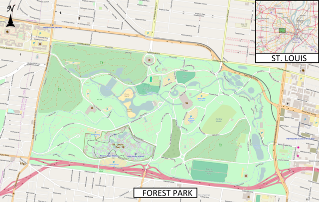
English: This map of Forest Park (St. Louis) was created from OpenStreetMap project data, collected by the community. The image should remain clear of any additional edits. To annotate the map for an article, use the Infobox or Location Map template and reference the map using map module Forest Park (St. Louis). This map may be incomplete, and may contain errors. Submit corrections to the below source link. Do not rely solely on the map for navigation. To the top right is an insert showing the location of the park within St. Louis.
|
| Date | |
| Source | http://www.openstreetmap.org |
| Author | OpenStreetMap contributors |
Licensing
This file is licensed under the Creative Commons Attribution-Share Alike 2.5 Generic license.
- You are free:
- to share – to copy, distribute and transmit the work
- to remix – to adapt the work
- Under the following conditions:
- attribution – You must give appropriate credit, provide a link to the license, and indicate if changes were made. You may do so in any reasonable manner, but not in any way that suggests the licensor endorses you or your use.
- share alike – If you remix, transform, or build upon the material, you must distribute your contributions under the same or compatible license as the original.
File history
Click on a date/time to view the file as it appeared at that time.
| Date/Time | Thumbnail | Dimensions | User | Comment | |
|---|---|---|---|---|---|
| current | 01:04, 10 November 2015 | | 1,955 × 1,238 (1.93 MB) | Jolly Janner | Added label for Turtle Park |
| 23:57, 9 November 2015 |  | 1,955 × 1,238 (1.93 MB) | Jolly Janner | =={{int:filedesc}}== {{Information |description={{en|1=This map of '''Forest Park (St. Louis)''' was created from OpenStreetMap project data, collected by the community. The image should remain clear of any additional ed... |
File usage
The following pages on the English Wikipedia use this file (pages on other projects are not listed):
Global file usage
The following other wikis use this file:
- Usage on ar.wikipedia.org
- Usage on ja.wikipedia.org
.png)