
File:French Hercynian massifs EN.svg

Size of this PNG preview of this SVG file: 800 × 555 pixels. Other resolutions: 320 × 222 pixels | 640 × 444 pixels | 1,024 × 711 pixels | 1,280 × 888 pixels | 2,560 × 1,777 pixels | 850 × 590 pixels.
Original file (SVG file, nominally 850 × 590 pixels, file size: 274 KB)
| This is a file from the Wikimedia Commons. Information from its description page there is shown below. Commons is a freely licensed media file repository. You can help. |
Summary
| Description |
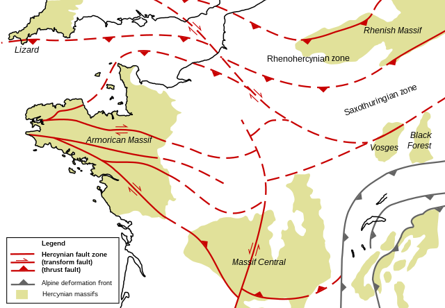
English: Structural geologic map of the north of France, showing Hercynian massifs and structures. Based on figures and information in the following literature:
|
| Date | |
| Source | Own work |
| Author | Woudloper |
| Other versions |
 |
Licensing
| I, the copyright holder of this work, release this work into the public domain. This applies worldwide. In some countries this may not be legally possible; if so: I grant anyone the right to use this work for any purpose, without any conditions, unless such conditions are required by law. |
File history
Click on a date/time to view the file as it appeared at that time.
| Date/Time | Thumbnail | Dimensions | User | Comment | |
|---|---|---|---|---|---|
| current | 21:37, 27 November 2008 | | 850 × 590 (274 KB) | Woudloper | {{Information |Description={{en|1=Structural geologic map of the north of France, showing Hercynian massifs and structures. Based on figures and information in the following literature: *{{aut|Service Géologique National}}; '''1996''': ''Carte géologiqu |
File usage
The following pages on the English Wikipedia use this file (pages on other projects are not listed):
Global file usage
The following other wikis use this file:
- Usage on ja.wikipedia.org
- Usage on ro.wikipedia.org
- Usage on uk.wikipedia.org
- Usage on zh.wikipedia.org