
File:Germanborders.png
No higher resolution available.
Germanborders.png (683 × 498 pixels, file size: 18 KB, MIME type: image/png)
| This is a file from the Wikimedia Commons. Information from its description page there is shown below. Commons is a freely licensed media file repository. You can help. |

|
This file has been superseded by Germanborders.svg. It is recommended to use the other file. Please note that deleting superseded images requires consent.
|

|

|
This map has been uploaded by Electionworld from en.wikipedia.org to enable the |
Summary
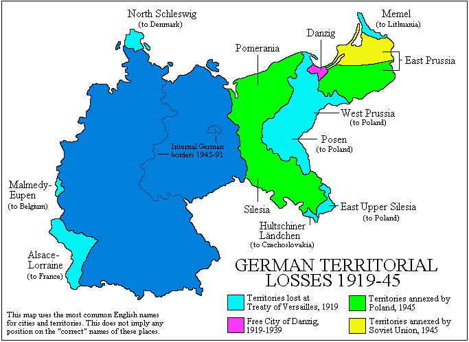
Map created by User:Adam Carr, June 2006
Map converted to PNG from the original GIF by User:GhePeU. GhePeU 11:57, 17 September 2007 (UTC)
Licensing
| I, the copyright holder of this work, release this work into the public domain. This applies worldwide. In some countries this may not be legally possible; if so: I grant anyone the right to use this work for any purpose, without any conditions, unless such conditions are required by law. |
File history
Click on a date/time to view the file as it appeared at that time.
| Date/Time | Thumbnail | Dimensions | User | Comment | |
|---|---|---|---|---|---|
| current | 14:12, 13 January 2008 | | 683 × 498 (18 KB) | JordiCuber | Corrections: The Isle of Sylt and Western Upper Silesia stayed with Germany |
| 11:56, 17 September 2007 |  | 683 × 498 (13 KB) | GhePeU | {{Information |Description= |Source= |Date= |Author= |Permission= |other_versions= }} |
File usage
The following pages on the English Wikipedia use this file (pages on other projects are not listed):
Global file usage
The following other wikis use this file:
- Usage on ro.wikipedia.org