
File:Goodwin Fire.png

Size of this preview: 600 × 600 pixels. Other resolutions: 240 × 240 pixels | 480 × 480 pixels | 768 × 768 pixels | 1,024 × 1,024 pixels | 2,048 × 2,048 pixels | 3,200 × 3,200 pixels.
Original file (3,200 × 3,200 pixels, file size: 3.97 MB, MIME type: image/png)
| This is a file from the Wikimedia Commons. Information from its description page there is shown below. Commons is a freely licensed media file repository. You can help. |
Summary
| Description |
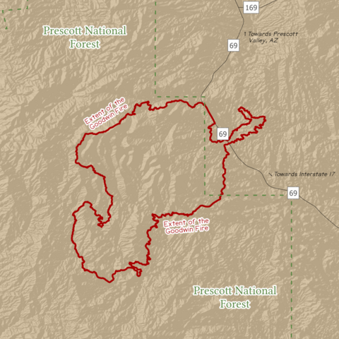
English: Scope of the Goodwin Wildfire according to the National Interagency Fire Center. |
||
| Date | |||
| Source | Own work | ||
| Creator | |||
| Credit line | © Tom Fish, geo.fish // Creative Commons BY-SA 4.0 | ||
| Permission (Reusing this file) |
|
||
| Geotemporal data | |||
| Spatial reference system | NAD 1983 UTM Zone 12N | ||
| Scale | 1:150,000 | ||
| Georeferencing | If inappropriate please set warp_status = skip to hide. | ||
| PNG development | This map was created with ArcGIS Pro. |
||
Licensing
Data and other credited works
Wildfire
Historic Perimeters Combined 2000-2018 GeoMAC
This work is in the public domain in the United States because it is a work prepared by an officer or employee of the United States Government as part of that person’s official duties under the terms of Title 17, Chapter 1, Section 105 of the US Code.
Note: This only applies to original works of the Federal Government and not to the work of any individual U.S. state, territory, commonwealth, county, municipality, or any other subdivision. This template also does not apply to postage stamp designs published by the United States Postal Service since 1978. (See § 313.6(C)(1) of Compendium of U.S. Copyright Office Practices). It also does not apply to certain US coins; see The US Mint Terms of Use.
|
 | |
| This file has been identified as being free of known restrictions under copyright law, including all related and neighboring rights. | ||
Hillshade
The hillshade was generated in QGIS based on 1/3 Arc Second DEM titles from the USGS
This image is in the public domain in the United States because it only contains materials that originally came from the United States Geological Survey, an agency of the United States Department of the Interior. For more information, see the official USGS copyright policy.
|
Roads
| This image is a work of a United States Department of Transportation employee, taken or made as part of that person's official duties. As a work of the U.S. federal government, the image is in the public domain. |
National Forest boundary
This image is a work of the Forest Service of the United States Department of Agriculture. As a work of the U.S. federal government, the image is in the public domain.
|
Final Map
I, the copyright holder of this work, hereby publish it under the following licenses:
This file is licensed under the Creative Commons Attribution-Share Alike 3.0 Unported license.
- You are free:
- to share – to copy, distribute and transmit the work
- to remix – to adapt the work
- Under the following conditions:
- attribution – You must give appropriate credit, provide a link to the license, and indicate if changes were made. You may do so in any reasonable manner, but not in any way that suggests the licensor endorses you or your use.
- share alike – If you remix, transform, or build upon the material, you must distribute your contributions under the same or compatible license as the original.
This file is licensed under the Creative Commons Attribution-Share Alike 4.0 International license.
- You are free:
- to share – to copy, distribute and transmit the work
- to remix – to adapt the work
- Under the following conditions:
- attribution – You must give appropriate credit, provide a link to the license, and indicate if changes were made. You may do so in any reasonable manner, but not in any way that suggests the licensor endorses you or your use.
- share alike – If you remix, transform, or build upon the material, you must distribute your contributions under the same or compatible license as the original.
You may select the license of your choice.
File history
Click on a date/time to view the file as it appeared at that time.
| Date/Time | Thumbnail | Dimensions | User | Comment | |
|---|---|---|---|---|---|
| current | 20:20, 17 February 2024 | | 3,200 × 3,200 (3.97 MB) | Guerillero | == {{int:filedesc}} == {{User:Guerillero/MapTemplate |Description= {{en|Scope of the Goodwin Wildfire according to the National Interagency Fire Center.}} |Date= 2024-02-17 |WURL= |WStatus= |Projection = NAD 1983 UTM Zone 12N |Scale = 1:15,000 }} == {{int:license-header}} == ===Data and other credited works=== ====Wildfire==== [https://data-nifc.opendata.arcgis.com/datasets/ef25d7e8c9f3499ba9e3d8e09606e488_0/explore Historic Perimeters Combined 2000-2018 GeoMAC] {{PD-USGov}} ====Hillshade... |
File usage
The following pages on the English Wikipedia use this file (pages on other projects are not listed):