
File:Grand Canyon, from about Mohawk to Whitmore Canyons, below the Uinkaret Volcanic Field.jpg

Size of this preview: 800 × 600 pixels. Other resolutions: 320 × 240 pixels | 640 × 480 pixels | 1,024 × 768 pixels | 1,280 × 960 pixels | 2,560 × 1,920 pixels | 3,264 × 2,448 pixels.
Original file (3,264 × 2,448 pixels, file size: 7.19 MB, MIME type: image/jpeg)
| This is a file from the Wikimedia Commons. Information from its description page there is shown below. Commons is a freely licensed media file repository. You can help. |
Summary
| Description |
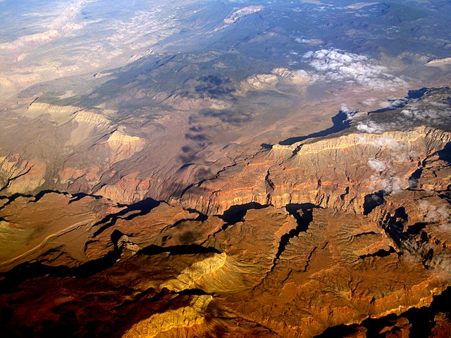
English: The Grand Canyon, from about Mohawk to Whitmore Canyons, below the Uinkaret Volcanic Field, and the lava flow over the rim (center left) from this volcanic field (center top). The lava flow into the gorge is en:Lava Falls, and creates one of the major river rapids, Lava Falls Rapids. The site is downdropped (to west, left) from the en:Toroweap Fault. The Hurricane Fault (to southwest Utah, see en:Hurricane Cliffs), begins here, and strikes west along the west side of the (small) Uinkaret Mountains-(north, en:Mount Trumbull Wilderness); the Toroweap Valley is just east. The Toroweap Fault strikes along the east of Toroweap Valley going north into border region of Utah. Across the river, south, the en:Aubrey Cliffs, (east border of Toroweap Fault), strikes south towards Aubrey Valley, and Seligman, AZ. The Aubrey Cliffs are the west perimeter of the en:Coconino Plateau-(the (east)-South Rim, Grand Canyon, down to Flagstaff, and the en:San Francisco volcanic field). |
| Date | |
| Source |
|
| Author | Doc Searls from Santa Barbara, USA |
Licensing
This file is licensed under the Creative Commons Attribution-Share Alike 2.0 Generic license.
- You are free:
- to share – to copy, distribute and transmit the work
- to remix – to adapt the work
- Under the following conditions:
- attribution – You must give appropriate credit, provide a link to the license, and indicate if changes were made. You may do so in any reasonable manner, but not in any way that suggests the licensor endorses you or your use.
- share alike – If you remix, transform, or build upon the material, you must distribute your contributions under the same or compatible license as the original.
| This image, originally posted to Flickr, was reviewed on May 27, 2009 by the administrator or reviewer File Upload Bot (Magnus Manske), who confirmed that it was available on Flickr under the stated license on that date. |
File history
Click on a date/time to view the file as it appeared at that time.
| Date/Time | Thumbnail | Dimensions | User | Comment | |
|---|---|---|---|---|---|
| current | 05:30, 26 January 2013 | | 3,264 × 2,448 (7.19 MB) | Slick-o-bot | Bot: convert to a non-interlaced jpeg (see bug #17645) |
| 02:16, 27 May 2009 |  | 3,264 × 2,448 (6.46 MB) | File Upload Bot (Magnus Manske) | {{Information |Description= The [http://en.wikipedia.org/wiki/Grand_Canyon Grand Canyon], from about Mohawk to Whitmore Canyons, below the [http://en.wikipedia.org/wiki/Uinkaret_volcanic_field Uinkaret Volcanic Field]. |Source=[http://www.flickr.com/phot |
File usage
The following pages on the English Wikipedia use this file (pages on other projects are not listed):
Global file usage
The following other wikis use this file:
- Usage on ceb.wikipedia.org
- Usage on cs.wikipedia.org
- Usage on de.wikipedia.org
- Usage on ml.wikipedia.org
- Usage on te.wikipedia.org
- Usage on www.wikidata.org