
File:Haughley station site geograph-3618172-by-Ben-Brooksbank.jpg

Size of this preview: 800 × 540 pixels. Other resolutions: 320 × 216 pixels | 640 × 432 pixels | 1,024 × 692 pixels | 1,280 × 865 pixels | 2,392 × 1,616 pixels.
Original file (2,392 × 1,616 pixels, file size: 3.36 MB, MIME type: image/jpeg)
| This is a file from the Wikimedia Commons. Information from its description page there is shown below. Commons is a freely licensed media file repository. You can help. |
Summary
| Description |
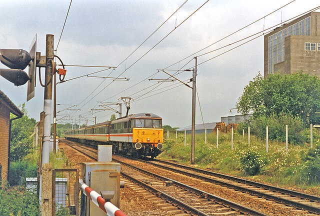
English: Site of Haughley station with train, 1997. View northward, towards Norwich and Bury St Edmunds, also Laxfield formerly: ex-GER London etc. - Ipswich - Norwich/Bury St Edmunds and Ely. The Mid-Suffolk Light Railway to Laxfield, which closed from 28/7/52, had its own platform on the right. Haughley station closed 2/1/67. The train is a Norwich - London Liverpool Street express, hauled by a Class 86 electric locomotive. |
| Date | |
| Source | From geograph.org.uk |
| Author | Ben Brooksbank |
| Permission (Reusing this file) |
Creative Commons Attribution Share-alike license 2.0 |
| Attribution (required by the license) | Ben Brooksbank / Site of Haughley station with train, 1997 / |
| Camera location | | View this and other nearby images on: OpenStreetMap |
|---|
Licensing

|
This image was taken from the Geograph project collection. See this photograph's page on the Geograph website for the photographer's contact details. The copyright on this image is owned by Ben Brooksbank and is licensed for reuse under the Creative Commons Attribution-ShareAlike 2.0 license.
|
This file is licensed under the Creative Commons Attribution-Share Alike 2.0 Generic license.
Attribution: Ben Brooksbank
- You are free:
- to share – to copy, distribute and transmit the work
- to remix – to adapt the work
- Under the following conditions:
- attribution – You must give appropriate credit, provide a link to the license, and indicate if changes were made. You may do so in any reasonable manner, but not in any way that suggests the licensor endorses you or your use.
- share alike – If you remix, transform, or build upon the material, you must distribute your contributions under the same or compatible license as the original.
File history
Click on a date/time to view the file as it appeared at that time.
| Date/Time | Thumbnail | Dimensions | User | Comment | |
|---|---|---|---|---|---|
| current | 07:51, 28 September 2013 | | 2,392 × 1,616 (3.36 MB) | Chevin | {{Information |Description ={{en|1=== {{int:license}} == {{geograph|3618172|Ben Brooksbank}}}} |Source === {{int:license}} == {{geograph|3618172|Ben Brooksbank}} |Author === {{int:license}} == {{geograph|3618172|Ben Brooksbank}} |D... |
File usage
The following pages on the English Wikipedia use this file (pages on other projects are not listed):
Global file usage
The following other wikis use this file:
- Usage on zh.wikipedia.org