
File:Heath geograph-3627754-by-Ben-Brooksbank.jpg

Size of this preview: 800 × 478 pixels. Other resolutions: 320 × 191 pixels | 640 × 383 pixels | 1,024 × 612 pixels | 1,280 × 765 pixels | 2,355 × 1,408 pixels.
Original file (2,355 × 1,408 pixels, file size: 2.64 MB, MIME type: image/jpeg)
| This is a file from the Wikimedia Commons. Information from its description page there is shown below. Commons is a freely licensed media file repository. You can help. |
Summary
| Description |
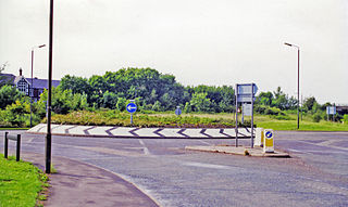
English: Heath: site of former main-line station. View NW on Hardwick Road at the A6175 roundabout, Heath station having been just the other side of the present roundabout. It was on the Sheffield via Staveley (to right) - (to left) Nottingham section of the ill-fated ex-GCR 'London Extension' main line; also the Chesterfield Loop on this route turned off a mile or so to the north (right), rejoining the through line at Staveley. The station was closed to passengers 4/3/63, when local services ceased (to goods on 12/6/65), but main line services continued until 5/9/66, with final closure on 11/9/67 |
| Date | |
| Source | From geograph.org.uk |
| Author | Ben Brooksbank |
| Permission (Reusing this file) |
Creative Commons Attribution Share-alike license 2.0 |
| Attribution (required by the license) | Ben Brooksbank / Heath: site of former main-line station / |
| Camera location | | View this and other nearby images on: OpenStreetMap |
|---|
Licensing

|
This image was taken from the Geograph project collection. See this photograph's page on the Geograph website for the photographer's contact details. The copyright on this image is owned by Ben Brooksbank and is licensed for reuse under the Creative Commons Attribution-ShareAlike 2.0 license.
|
This file is licensed under the Creative Commons Attribution-Share Alike 2.0 Generic license.
Attribution: Ben Brooksbank
- You are free:
- to share – to copy, distribute and transmit the work
- to remix – to adapt the work
- Under the following conditions:
- attribution – You must give appropriate credit, provide a link to the license, and indicate if changes were made. You may do so in any reasonable manner, but not in any way that suggests the licensor endorses you or your use.
- share alike – If you remix, transform, or build upon the material, you must distribute your contributions under the same or compatible license as the original.
File history
Click on a date/time to view the file as it appeared at that time.
| Date/Time | Thumbnail | Dimensions | User | Comment | |
|---|---|---|---|---|---|
| current | 10:25, 1 October 2013 | | 2,355 × 1,408 (2.64 MB) | Chevin | == {{int:filedesc}} == {{Information |Description={{en|1='''Heath: site of former main-line station.'''<br/> View NW on Hardwick Road at the A6175 roundabout, Heath station having been just the other side of the present roundabout. It was on the Sheffi... |
File usage
The following pages on the English Wikipedia use this file (pages on other projects are not listed):