
File:Hebao island map.jpg
Size of this preview: 752 × 600 pixels. Other resolutions: 301 × 240 pixels | 602 × 480 pixels | 999 × 797 pixels.
Original file (999 × 797 pixels, file size: 156 KB, MIME type: image/jpeg)
| This is a file from the Wikimedia Commons. Information from its description page there is shown below. Commons is a freely licensed media file repository. You can help. |
| Description |
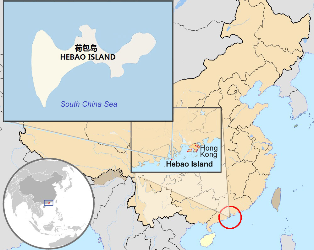
English: Map showing Zhuhai's Hebao Island's location in Asia, off China's south coast, and in relation to Hong Kong
Français : Carte de l'fr:île Hébāo à Zhuhai : situation en Asie, situation sur le littoral chinois
中文:珠海市荷包岛地图 |
| Date | (UTC) |
| Source | |
| Author |
|
| Other versions | Derivative works of this file: Damang island china location map.jpg |
| This is a retouched picture, which means that it has been digitally altered from its original version. Modifications: Modified to show location of Hebao Dao (Purse Island). The original can be viewed here: China Hong Kong 4 levels localisation.svg:
|
I, the copyright holder of this work, hereby publish it under the following license:
This file is licensed under the Creative Commons Attribution-Share Alike 3.0 Unported license.
- You are free:
- to share – to copy, distribute and transmit the work
- to remix – to adapt the work
- Under the following conditions:
- attribution – You must give appropriate credit, provide a link to the license, and indicate if changes were made. You may do so in any reasonable manner, but not in any way that suggests the licensor endorses you or your use.
- share alike – If you remix, transform, or build upon the material, you must distribute your contributions under the same or compatible license as the original.
Original upload log
This image is a derivative work of the following images:
- File:China_Hong_Kong_4_levels_localisation.svg licensed with Cc-by-sa-3.0
- 2010-03-05T18:40:15Z Pethrus 1000x850 (701299 Bytes) {{Information |Description={{en|1=Map showing Hong Kong's location in Asia, on China's south coast, and Hong Kong's 18 disctricts}} {{fr|1=Carte de Hong Kong : situation en Asie, situation sur le littoral chinois, carte des 1
Uploaded with derivativeFX
File history
Click on a date/time to view the file as it appeared at that time.
| Date/Time | Thumbnail | Dimensions | User | Comment | |
|---|---|---|---|---|---|
| current | 16:13, 3 October 2010 | | 999 × 797 (156 KB) | Christinebenson58 | {{Information |Description={{en|1=Map showing Hong Kong's location in Asia, on China's south coast, and Hong Kong's 18 disctricts}} {{fr|1=Carte de Hong Kong : situation en Asie, situation sur le littoral chinois, carte des 18 disctricts}} |Source=*[[:Fil |
File usage
The following pages on the English Wikipedia use this file (pages on other projects are not listed):
Global file usage
The following other wikis use this file:
- Usage on ceb.wikipedia.org
- Usage on es.wikipedia.org
- Usage on sv.wikipedia.org
- Usage on www.wikidata.org
- Usage on zh.wikipedia.org