
File:Hering lon-sewer-det02 1882.jpg

Size of this preview: 800 × 565 pixels. Other resolutions: 320 × 226 pixels | 640 × 452 pixels | 1,024 × 723 pixels | 1,103 × 779 pixels.
Original file (1,103 × 779 pixels, file size: 441 KB, MIME type: image/jpeg)
| This is a file from the Wikimedia Commons. Information from its description page there is shown below. Commons is a freely licensed media file repository. You can help. |
Summary
| Description |
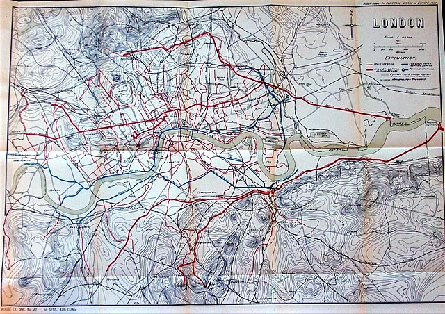
English: Map of the London sewerage system developed by Joseph Bazalgette 1858–1870. Subtitled "House Ex. Doc. №27 for Sess. 47th Cong. Downloaded from Rootsweb
The colours are: High-level sewers (thicker being the interceptor sewers) and northern and southern outfall sewers
Low-level interceptor sewers
|
| Date | |
| Source | Sewerage Works in Europe |
| Author | Rudolf Hering, 1882 |
Licensing
|
This work is in the public domain in its country of origin and other countries and areas where the copyright term is the author's life plus 70 years or fewer. This work is in the public domain in the United States because it was published (or registered with the U.S. Copyright Office) before January 1, 1929. | |
| This file has been identified as being free of known restrictions under copyright law, including all related and neighboring rights. | |
File history
Click on a date/time to view the file as it appeared at that time.
| Date/Time | Thumbnail | Dimensions | User | Comment | |
|---|---|---|---|---|---|
| current | 16:57, 29 April 2021 | | 1,103 × 779 (441 KB) | Adam37 | cropped and saturated |
| 16:02, 4 April 2015 |  | 1,173 × 829 (323 KB) | Chris55 | the whole map as originally intended | |
| 15:54, 4 April 2015 |  | 1,269 × 885 (438 KB) | Chris55 | User created page with UploadWizard |
File usage
The following pages on the English Wikipedia use this file (pages on other projects are not listed):
Global file usage
The following other wikis use this file:
- Usage on mr.wikipedia.org
- Usage on ur.wikipedia.org