
File:Hidden Valley Raceway (Australia) track map.svg

Size of this PNG preview of this SVG file: 800 × 443 pixels. Other resolutions: 320 × 177 pixels | 640 × 354 pixels | 1,024 × 567 pixels | 1,280 × 709 pixels | 2,560 × 1,418 pixels | 1,459 × 808 pixels.
Original file (SVG file, nominally 1,459 × 808 pixels, file size: 39 KB)
| This is a file from the Wikimedia Commons. Information from its description page there is shown below. Commons is a freely licensed media file repository. You can help. |
_track_map.svg)
Summary
| Description |
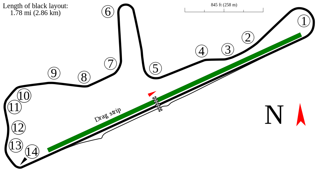
English: Track map for use with Hidden Valley Raceway. Map based on data from January 1st, 2006. |
| Date | |
| Source | Own work |
| Author | Will Pittenger / wlps-ge-stuff.ucoz.com |

|
Attribution information, such as the author's name, e-mail, website, or signature, that was once visible in the image itself has been moved into the image metadata and/or image description page. This makes the image easier to reuse and more language-neutral, and makes the text easier to process and search for. Commons discourages placing visible author information in images.
|
This W3C-unspecified vector image was created with Inkscape .
| Camera location | | View this and other nearby images on: OpenStreetMap |
|---|
_track_map.svg¶ms=-12.447889_N_0130.907639_E_globe:Earth_type:camera__&language=en)
Licensing
I, the copyright holder of this work, hereby publish it under the following license:
This file is licensed under the Creative Commons Attribution-Share Alike 3.0 Unported license.
- You are free:
- to share – to copy, distribute and transmit the work
- to remix – to adapt the work
- Under the following conditions:
- attribution – You must give appropriate credit, provide a link to the license, and indicate if changes were made. You may do so in any reasonable manner, but not in any way that suggests the licensor endorses you or your use.
- share alike – If you remix, transform, or build upon the material, you must distribute your contributions under the same or compatible license as the original.
File history
Click on a date/time to view the file as it appeared at that time.
| Date/Time | Thumbnail | Dimensions | User | Comment | |
|---|---|---|---|---|---|
| current | 00:06, 27 March 2012 | | 1,459 × 808 (39 KB) | Jbarta | remove credit & data source text, this info should be in the image description, not in the image itself |
| 02:22, 23 March 2012 |  | 1,459 × 808 (35 KB) | Quibik | Reverted to version as of 21:59, 27 June 2010 | |
| 02:19, 23 March 2012 |  | 1,459 × 808 (9 KB) | Quibik | Removed unnecessary text. Optimized. | |
| 21:59, 27 June 2010 |  | 1,459 × 808 (35 KB) | Will Pittenger | {{Information |Description={{en|1=Track map for use with w:Hidden Valley Raceway}} |Source={{own}} |Author=Will Pittenger |Date=2010-06-27 |Permission= |other_versions= }} {{Inkscape}} {{Location|12|26|52.4|S|130|54|27.5|E} |
File usage
The following pages on the English Wikipedia use this file (pages on other projects are not listed):
- 2001 V8 Supercars Darwin round
- 2006 Darwin Triple Crown
- 2007 Darwin Triple Crown
- 2008 Darwin Triple Crown
- 2009 Darwin Triple Crown
- 2010 Skycity Triple Crown
- 2011 Skycity Triple Crown
- 2012 Skycity Triple Crown
- 2013 Skycity Triple Crown
- 2014 Skycity Triple Crown
- 2015 Skycity Triple Crown
- 2016 CrownBet Darwin Triple Crown
- 2017 Darwin Triple Crown
- 2018 Darwin Triple Crown
- 2019 Darwin Triple Crown
- 2021 Darwin Triple Crown
- 2022 Darwin Triple Crown
- Darwin Triple Crown
- Hidden Valley Raceway
- List of Australian Touring Car Championship circuits
- Template:Infobox V8 Supercar race report/testcases
Global file usage
The following other wikis use this file:
- Usage on de.wikipedia.org
- Usage on hu.wikipedia.org
- Usage on ja.wikipedia.org
- Usage on nl.wikipedia.org
- Usage on sv.wikipedia.org
- Usage on www.wikidata.org
_track_map.svg)