
File:Hungary-CIA WFB Map.png
No higher resolution available.
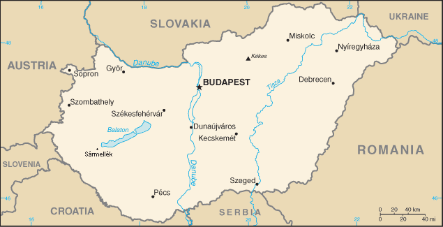
Hungary-CIA_WFB_Map.png (635 × 325 pixels, file size: 16 KB, MIME type: image/png)
| This is a file from the Wikimedia Commons. Information from its description page there is shown below. Commons is a freely licensed media file repository. You can help. |
.png)
This image is in the public domain because it contains materials that originally came from the United States Central Intelligence Agency's World Factbook.
|
 |
File history
Click on a date/time to view the file as it appeared at that time.
| Date/Time | Thumbnail | Dimensions | User | Comment | |
|---|---|---|---|---|---|
| current | 21:32, 1 November 2010 | | 635 × 325 (16 KB) | Fakirbakir | Sármellék |
| 04:46, 1 July 2006 |  | 635 × 325 (16 KB) | Hoshie | Updated map of Hungary from the CIA World Factbook, 29 June 06 rev. http://www.cia.gov/cia/publications/factbook/maps/hu-map.gif | |
| 09:14, 27 March 2005 |  | 635 × 324 (14 KB) | Wolfman~commonswiki | {{CIA-map}} |
File usage
The following pages on the English Wikipedia use this file (pages on other projects are not listed):
Global file usage
The following other wikis use this file:
- Usage on az.wikipedia.org
- Usage on ban.wikipedia.org
- Usage on bn.wikipedia.org
- Usage on bs.wikipedia.org
- Usage on ca.wikipedia.org
- Usage on el.wikipedia.org
- Usage on en.wikisource.org
- Usage on fa.wikipedia.org
- Usage on fr.wikipedia.org
- Usage on ilo.wikipedia.org
- Usage on ja.wikipedia.org
- Usage on ka.wikipedia.org
- Usage on kn.wikipedia.org
- Usage on lt.wikipedia.org
- Usage on ml.wikipedia.org
- Usage on nn.wikipedia.org
- Usage on pl.wikipedia.org
- Usage on ru.wikipedia.org
- Usage on simple.wikipedia.org
- Usage on si.wikipedia.org
- Usage on sl.wikipedia.org
- Usage on th.wikipedia.org
- Usage on uz.wikipedia.org
- Usage on yi.wikipedia.org
- Usage on zh.wikipedia.org