
File:ITV Westcountry 2009-2013 locator map.svg

Size of this PNG preview of this SVG file: 413 × 600 pixels. Other resolutions: 165 × 240 pixels | 330 × 480 pixels | 529 × 768 pixels | 705 × 1,024 pixels | 1,410 × 2,048 pixels | 685 × 995 pixels.
Original file (SVG file, nominally 685 × 995 pixels, file size: 383 KB)
| This is a file from the Wikimedia Commons. Information from its description page there is shown below. Commons is a freely licensed media file repository. You can help. |
Summary
| Description |
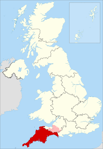
English: Map highlighting the former ITV Westcountry franchise region amongst all other UK ITV regions in 2013 |
| Date | |
| Source |
This file was derived from: United Kingdom location map.svg:  |
| Author |
|
References
- "ITV Anglia micro regions", 2009, ITV Media, archived 16 December 2009
- "ITV Border region", 2009, ITV Media, archived 28 July 2009
- "ITV Central micro regions", 2009, ITV Media, archived 15 December 2009
- "ITV Granada region", 2009, ITV Media, archived 15 December 2009
- "ITV London region", 2009, ITV Media, archived 13 December 2009
- "ITV Meridian micro regions", 2009, ITV Media, archived 12 December 2009
- "STV Central micro regions", 2009, ITV Media, archived 29 July 2009
- "STV North micro regions", 2009, ITV Media, archived 29 July 2009
- "ITV Tyne Tees micro regions", 2009, ITV Media, archived 15 December 2009
- "ITV Ulster region", 2009, ITV Media, archived 18 July 2009
- "ITV Wales region", 2009, ITV Media, archived 21 February 2010
- "ITV Westcountry region", 2009, ITV Media, archived 16 December 2009
- "ITV Yorkshire micro regions", 2009, ITV Media, archived 16 December 2009
- "ITV West region", 2009, ITV Media, archived 15 December 2009
Licensing
This file is licensed under the Creative Commons Attribution-Share Alike 4.0 International license.
Attribution: Dr Greg and NordNordWest
- You are free:
- to share – to copy, distribute and transmit the work
- to remix – to adapt the work
- Under the following conditions:
- attribution – You must give appropriate credit, provide a link to the license, and indicate if changes were made. You may do so in any reasonable manner, but not in any way that suggests the licensor endorses you or your use.
- share alike – If you remix, transform, or build upon the material, you must distribute your contributions under the same or compatible license as the original.
File history
Click on a date/time to view the file as it appeared at that time.
| Date/Time | Thumbnail | Dimensions | User | Comment | |
|---|---|---|---|---|---|
| current | 20:06, 22 February 2019 | | 685 × 995 (383 KB) | Dr Greg | Add overlap with adjacent regions |
| 19:39, 5 February 2019 |  | 685 × 995 (361 KB) | Dr Greg | User created page with UploadWizard |
File usage
The following pages on the English Wikipedia use this file (pages on other projects are not listed):
Global file usage
The following other wikis use this file:
- Usage on zh.wikipedia.org