
File:Imagen Satelital Ipiales - 20220908.png
Size of this preview: 800 × 450 pixels. Other resolutions: 320 × 180 pixels | 640 × 360 pixels | 1,024 × 576 pixels | 1,280 × 720 pixels | 2,175 × 1,223 pixels.
Original file (2,175 × 1,223 pixels, file size: 6.43 MB, MIME type: image/png)
| This is a file from the Wikimedia Commons. Information from its description page there is shown below. Commons is a freely licensed media file repository. You can help. |
Summary
| Description |
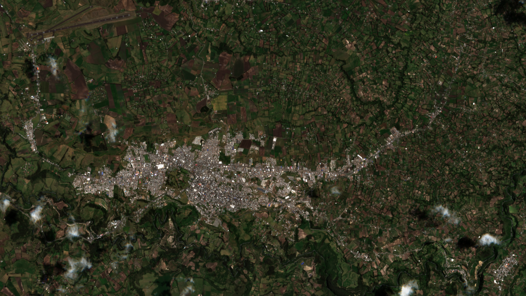
Español: La imagen corresponde a una toma satelital del casco urbano del municipio de Ipiales y sus alrededores, en el Departamento de Nariño, República de Colombia. El plano aproximado cubre 95.2 Km cuadrados, para un perímetro total aproximado de 40,61 Km; largo aproximado = 13,05 Km. y ancho aproximado = 7,29 Km en el plano de la foto, sin considerar las variaciones del terreno. En la imagen se distinguen elementos como: El área de más de 30 hectáreas del batallón del Ejército Nacional Grupo Mecanizado Número 3 Cabal, en el centro de la ciudad. El cañón del río Guáitara al sur (inferior de la imagen). El corregimiento de Las Lajas en el borde del mismo río y el vecino municipio de Potosí, en el extremo inferior derecho de la foto. Barrio Balcones de La Frontera, en el extremo izquierdo de la imagen. Aeropuerto San Luis, con sus dos pistas de aterrizaje, en el extremo superior izquierdo. Zonas de desarrollo y dispersión urbana aledañas a la salida a las principales vías de comunicación, principalmente la vía Panamericana Norte. |
| Date | |
| Source | U.S. Geological Survey. |
| Author | Landsat-2 image courtesy of the U.S. Geological Survey. |
Licensing
This work is in the public domain in the United States because it is a work prepared by an officer or employee of the United States Government as part of that person’s official duties under the terms of Title 17, Chapter 1, Section 105 of the US Code.
Note: This only applies to original works of the Federal Government and not to the work of any individual U.S. state, territory, commonwealth, county, municipality, or any other subdivision. This template also does not apply to postage stamp designs published by the United States Postal Service since 1978. (See § 313.6(C)(1) of Compendium of U.S. Copyright Office Practices). It also does not apply to certain US coins; see The US Mint Terms of Use.
|
 | |
| This file has been identified as being free of known restrictions under copyright law, including all related and neighboring rights. | ||
File history
Click on a date/time to view the file as it appeared at that time.
| Date/Time | Thumbnail | Dimensions | User | Comment | |
|---|---|---|---|---|---|
| current | 06:04, 15 February 2023 | | 2,175 × 1,223 (6.43 MB) | Geomarcowik | Uploaded a work by Landsat-2 image courtesy of the U.S. Geological Survey. from U.S. Geological Survey. with UploadWizard |
File usage
The following pages on the English Wikipedia use this file (pages on other projects are not listed):