
File:Jacob's Post - geograph.org.uk - 1456506.jpg
Size of this preview: 450 × 600 pixels. Other resolutions: 180 × 240 pixels | 480 × 640 pixels.
Original file (480 × 640 pixels, file size: 162 KB, MIME type: image/jpeg)
| This is a file from the Wikimedia Commons. Information from its description page there is shown below. Commons is a freely licensed media file repository. You can help. |
Summary
| Description |
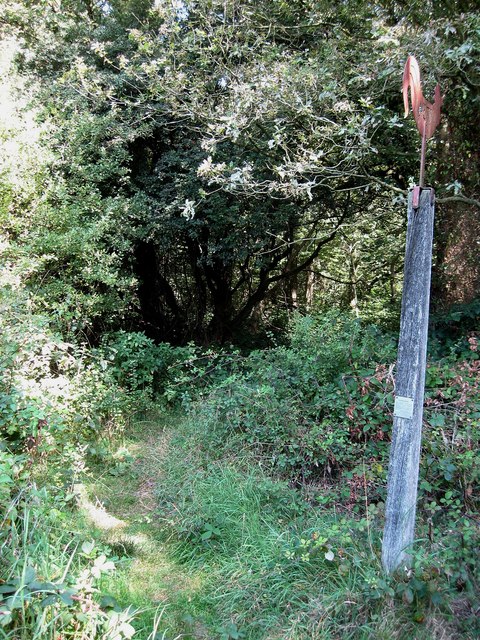
English: Jacob's Post. The metal bird attached to the top of the post has the date 1734 on it. The post is a reminder of a foul deed committed nearby on that date. An itinerant pedlar named Jacob Harris (Alternatively known by his Jewish name of Yacob Hirsch) lay in wait on the night 26th May to let all the customers leave the nearby 1446441 before returning to attack the landlord, Richard Miles, and his wife and their maid. The latter two died of their stabbing wounds whilst Miles was mortally wounded. Harris stole a coat worth ten shillings and when he discovered the supposedly dead Miles had disappeared, at which point he scarpered heading north to Turners Hill where he stayed at the Cat Inn. Although he had been stabbed in the throat and face Miles had been able to stagger to get help nearby and was able to identify his attacker who was a regular customer at the Royal Oak. A search party of soldiers was sent out to look for him and inadvertently discovered him at Selsfield House where they had retired from the rainy night, lit a fire that flushed him out of the chimney he was hiding in. Harris was tried and executed in Horsham and his body returned to hang in a gibbet at the northern end of Ditchling Common next to the highway and near the scene of his crime. The post itself took on a life of its own as people believed infertility and other ailments could be cured by touching the post and subsequently took away small pieces when visiting. This continued well into the 19th century despite the original post being replaced by another. The post used to be visible from the road but the common here has returned to scrub and has to be accessed via a track that starts next to the Royal Oak or from the farm drive or nearby Bankside Farm. |
| Date | |
| Source | From geograph.org.uk |
| Author | Simon Carey |
| Attribution (required by the license) | Simon Carey / Jacob's Post / |
| Camera location | | View this and other nearby images on: OpenStreetMap |
|---|
_heading:90.00&language=en)
| Object location | | View this and other nearby images on: OpenStreetMap |
|---|
_heading:90.00&language=en)
Licensing

|
This image was taken from the Geograph project collection. See this photograph's page on the Geograph website for the photographer's contact details. The copyright on this image is owned by Simon Carey and is licensed for reuse under the Creative Commons Attribution-ShareAlike 2.0 license.
|
This file is licensed under the Creative Commons Attribution-Share Alike 2.0 Generic license.
Attribution: Simon Carey
- You are free:
- to share – to copy, distribute and transmit the work
- to remix – to adapt the work
- Under the following conditions:
- attribution – You must give appropriate credit, provide a link to the license, and indicate if changes were made. You may do so in any reasonable manner, but not in any way that suggests the licensor endorses you or your use.
- share alike – If you remix, transform, or build upon the material, you must distribute your contributions under the same or compatible license as the original.
File history
Click on a date/time to view the file as it appeared at that time.
| Date/Time | Thumbnail | Dimensions | User | Comment | |
|---|---|---|---|---|---|
| current | 05:32, 2 March 2011 | | 480 × 640 (162 KB) | GeographBot | == {{int:filedesc}} == {{Information |description={{en|1=Jacob's Post The metal bird attached to the top of the post has the date 1734 on it. The post is a reminder of a foul deed committed nearby on that date. An itinerant pedlar named Jacob Harris (Alte |
File usage
The following pages on the English Wikipedia use this file (pages on other projects are not listed):
Global file usage
The following other wikis use this file:
- Usage on www.wikidata.org