
File:Jarvenpaa neighbourhoods.jpg

Original file (645 × 735 pixels, file size: 133 KB, MIME type: image/jpeg)
| This is a file from the Wikimedia Commons. Information from its description page there is shown below. Commons is a freely licensed media file repository. You can help. |
Summary
| Description |
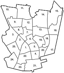
English: A map of neighbourhoods in the city of Järvenpää. The names of the individual neighbourhoods are listed below. The official statistical district numbers are in parenthesis after the name. |
| Date | |
| Source | Own work |
| Author | Heikki Narko |
Licensing
- You are free:
- to share – to copy, distribute and transmit the work
- to remix – to adapt the work
- Under the following conditions:
- attribution – You must give appropriate credit, provide a link to the license, and indicate if changes were made. You may do so in any reasonable manner, but not in any way that suggests the licensor endorses you or your use.
- share alike – If you remix, transform, or build upon the material, you must distribute your contributions under the same or compatible license as the original.
File history
Click on a date/time to view the file as it appeared at that time.
| Date/Time | Thumbnail | Dimensions | User | Comment | |
|---|---|---|---|---|---|
| current | 01:43, 4 June 2020 | | 645 × 735 (133 KB) | Saarik | updated the district numbers on the map |
| 19:47, 21 March 2007 |  | 645 × 735 (113 KB) | Heycci | {{Information |Description=English: A map of neighbourhoods in the city of Järvenpää. |Source=Own work |Date=21.3.2007 |Author=Heikki Narko |Permission= |other_versions= }} |
File usage
Global file usage
The following other wikis use this file:
- Usage on cs.wikipedia.org
- Usage on es.wikipedia.org
- Usage on fi.wikipedia.org
- Usage on fr.wikipedia.org
- Usage on gl.wikipedia.org
- Usage on sco.wikipedia.org
- Usage on sk.wikipedia.org
- Usage on smn.wikipedia.org
- Usage on vep.wikipedia.org
- Usage on www.wikidata.org