
File:Kansai Airport Map.png

Size of this preview: 800 × 504 pixels. Other resolutions: 320 × 201 pixels | 640 × 403 pixels | 1,024 × 645 pixels | 1,280 × 806 pixels | 2,560 × 1,612 pixels | 4,500 × 2,833 pixels.
Original file (4,500 × 2,833 pixels, file size: 970 KB, MIME type: image/png)
| This is a file from the Wikimedia Commons. Information from its description page there is shown below. Commons is a freely licensed media file repository. You can help. |
Summary
| Description |
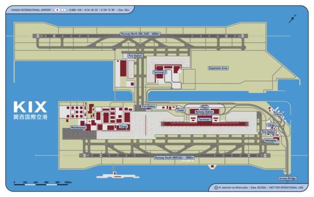
English: Osaka Kansai International Airport Map
Deutsch: Karte Flughafen Osaka Kansai |
| Date | |
| Source | Own work |
| Author | CellarDoor85 (Robert Aehnelt) |
| Permission (Reusing this file) |
I, the copyright holder of this work, hereby publish it under the following license: This file is licensed under the Creative Commons Attribution 3.0 Unported license.
|
File history
Click on a date/time to view the file as it appeared at that time.
| Date/Time | Thumbnail | Dimensions | User | Comment | |
|---|---|---|---|---|---|
| current | 17:39, 10 December 2016 | | 4,500 × 2,833 (970 KB) | DerLudonaut | {{Information |Description ={{en|1=Osaka Kansai International Airport Map}} {{de|1=Karte Flughafen Osaka Kansai}} |Source ={{own}} |Author =CellarDoor85 (Robert Aehnelt) |Date =2012-12 |Permission... |
File usage
The following pages on the English Wikipedia use this file (pages on other projects are not listed):
Global file usage
The following other wikis use this file:
- Usage on ast.wikipedia.org
- Usage on bn.wikipedia.org
- Usage on ca.wikipedia.org
- Usage on de.wikipedia.org
- Usage on eu.wikipedia.org
- Usage on fr.wikipedia.org
- Usage on ja.wikipedia.org
- Usage on la.wikipedia.org
- Usage on vi.wikipedia.org
- Usage on www.wikidata.org