
File:Kiev map english.png

Size of this preview: 601 × 599 pixels. Other resolutions: 241 × 240 pixels | 481 × 480 pixels | 770 × 768 pixels | 1,027 × 1,024 pixels | 2,054 × 2,048 pixels | 3,990 × 3,978 pixels.
Original file (3,990 × 3,978 pixels, file size: 11.87 MB, MIME type: image/png)
| This is a file from the Wikimedia Commons. Information from its description page there is shown below. Commons is a freely licensed media file repository. You can help. |
Summary
| Description |
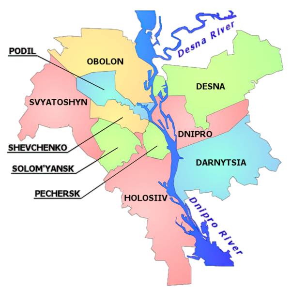
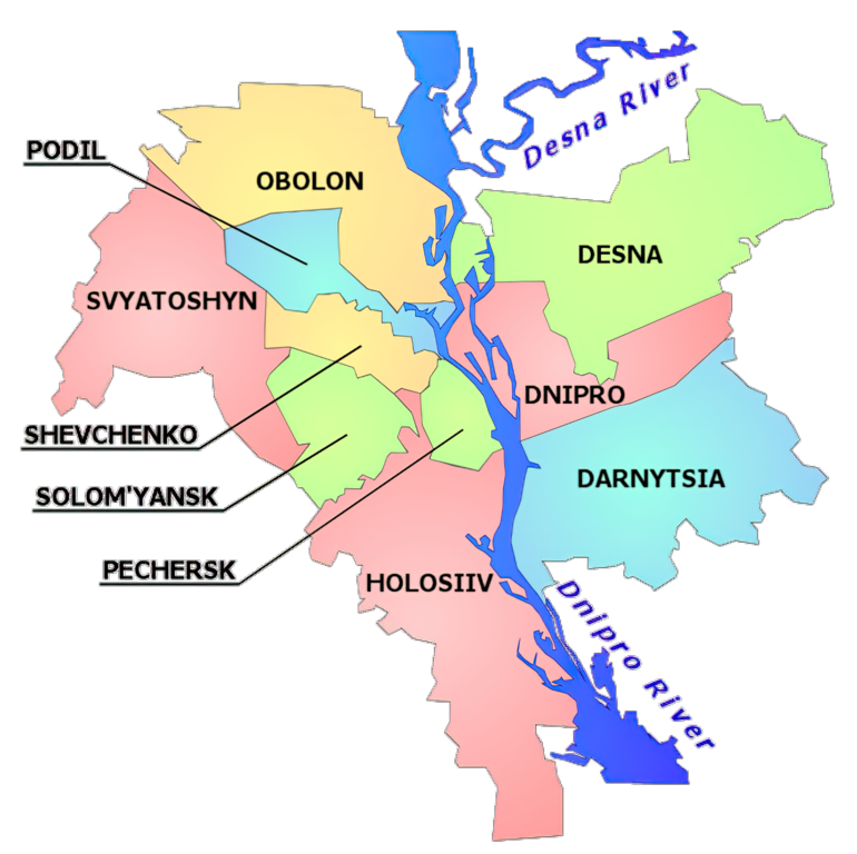
English: Map of Kyiv separated into raions, with Dnipro and Desna rivers, labelled in English |
|||
| Date | ||||
| Source | Own work | |||
| Author | Mno | |||
| Other versions |
|

.svg)
Licensing
Mno at the English Wikipedia, the copyright holder of this work, hereby publishes it under the following license:

|
Permission is granted to copy, distribute and/or modify this document under the terms of the GNU Free Documentation License, Version 1.2 or any later version published by the Free Software Foundation; with no Invariant Sections, no Front-Cover Texts, and no Back-Cover Texts. A copy of the license is included in the section entitled GNU Free Documentation License. |
If this file is eligible for relicensing, it may also be used under the Creative Commons Attribution-ShareAlike 3.0 license. The relicensing status of this image has not yet been reviewed. You can help.
|
Original upload log
The original description page was here. All following user names refer to en.wikipedia.
- 2005-12-28 19:59 Mno 665×663× (134079 bytes) Map of Kiev separated into raions, with Dnipro and Desna rivers, labelled in Englush. Small corrections to river in the south, single-color transparency. Author: [[User:mno ]]- me.
- 2005-12-28 19:36 Mno 667×663× (124742 bytes) Map of Kiev separated into raions, with Dnipro and Desna rivers, labelled in Englush. Author: [[User:mno]] - me.
File history
Click on a date/time to view the file as it appeared at that time.
| Date/Time | Thumbnail | Dimensions | User | Comment | |
|---|---|---|---|---|---|
| current | 22:12, 3 March 2022 | | 3,990 × 3,978 (11.87 MB) | OgreBot | (BOT): Reverting to most recent version before archival |
| 22:12, 3 March 2022 |  | 667 × 663 (122 KB) | OgreBot | (BOT): Uploading old version of file from en.wikipedia; originally uploaded on 2005-12-28 19:36:08 by Mno | |
| 04:19, 18 September 2021 |  | 3,990 × 3,978 (11.87 MB) | Athosmera | AI upscale | |
| 16:26, 4 September 2006 |  | 665 × 663 (103 KB) | D0ktorz | smaller | |
| 20:50, 2 September 2006 |  | 665 × 663 (131 KB) | DDima | Map of Kiev separated into raions, with Dnipro and Desna rivers, labelled in English. Author: User:mno - me. {{GFDL-self}} Category:Maps of Kiev |
File usage
The following pages on the English Wikipedia use this file (pages on other projects are not listed):
Global file usage
The following other wikis use this file:
- Usage on be.wikipedia.org
- Usage on ca.wikipedia.org
- Usage on cs.wikipedia.org
- Usage on cv.wikipedia.org
- Usage on de.wikipedia.org
- Usage on en.wikivoyage.org
- Usage on es.wikipedia.org
- Usage on fi.wikipedia.org
- Usage on fr.wikipedia.org
View more global usage of this file.