
File:Lake Charles NEXRAD after hurricane Laura.jpg

Size of this preview: 450 × 600 pixels. Other resolutions: 180 × 240 pixels | 360 × 480 pixels | 576 × 768 pixels | 768 × 1,024 pixels | 1,536 × 2,048 pixels | 3,024 × 4,032 pixels.
Original file (3,024 × 4,032 pixels, file size: 1.11 MB, MIME type: image/jpeg)
| This is a file from the Wikimedia Commons. Information from its description page there is shown below. Commons is a freely licensed media file repository. You can help. |
Summary
| Description |
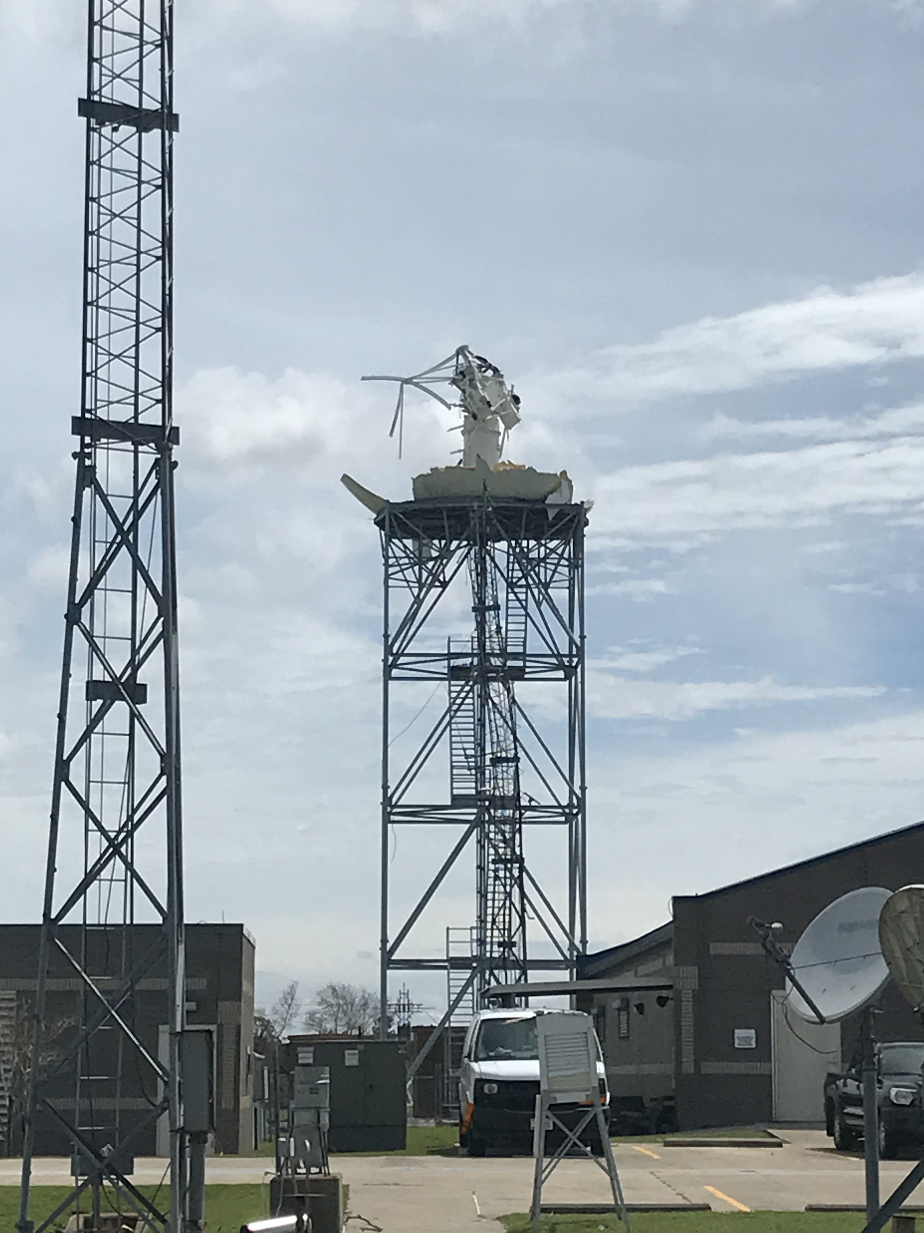
Français : Le service météorologique national de Lake Charles, en Louisiane, a enregistré une rafale de vent maximale de 116 nœuds (133 mi / h) à 1 h 42 HAC avant la panne de l'équipement éolien ASOS (station météorologique automatique). Cependant, le baromètre de l'ASOS qui était en toute sécurité dans le bâtiment du NWS (qui a reçu très peu de dégâts) a enregistré une pression minimale au niveau de la mer de 956 hPa à 02h20 CDT lorsque l'oeil de l'ouragan Laura est passé presque au-dessus. Le radar météorologique WSR-88D de Lake Charles, co-localisé avec le bureau, a enregistré son image finale à 00h53 HAC. Lors de l'inspection par le personnel du bureau de Lake Charles, il fut découvert que l'arrachement du radôme du WSR-88D s'est produite quand les vents violents du mur de l'eil ont soufflés directement sur le site.
English: The National Weather Service in Lake Charles, Louisiana recorded a station record highest peak wind gust of 116 knots (133 mph) at 1:42 AM CDT before the ASOS (Automated Surface Observing System) wind equipment failed. However, the ASOS barometer sensor that was safely within the NWS building (which received very little damage) recorded a station record minimum sea level pressure of 956 millibars (28.23 inches of mercury) at 2:20 AM CDT when the eye of Hurricane Laura passed nearly overhead. The Lake Charles, LA WSR-88D recorded the final radar image at 12:53 AM CDT. Upon first inspection of the National Weather Service Lake Charles station discovered the WSR-88D radome failure within the high winds of the eyewall. |
| Date | |
| Source | https://www.weather.gov/images/lch/events/2020Laura/20200827-120719.jpg in the article |
| Author | Lake Charles Office of the US National Weather Service |
| Camera location | | View this and other nearby images on: OpenStreetMap |
|---|
Licensing
This image is in the public domain because it was stored on the web servers of the U.S. National Weather Service. NWS-created images are automatically public domain in the U.S. since the NWS is a part of the U.S. government. However, the NWS sites also host non-NWS images which have been submitted by individuals: these are generally shown as "Courtesy of ...". Such images have explicitly been released to the public domain by the copyright owner as part of the upload process.
As stated at https://www.weather.gov/fsd/disclaimer: "By submitting images, you understand that your image is being released into the public domain. This means that your photo or video may be downloaded, copied, and used by others." Thus, all* images on NWS servers are public domain (including "Courtesy of ..." and “Photo by ...” images) unless specifically stated otherwise through a copyright (©) watermark.
*A deletion discussion in November 2023 ruled that Getty Images on the web servers of NWS, are to be considered copyrighted, even without a copyright (©) watermark and are the sole exception to this rule.
|
File history
Click on a date/time to view the file as it appeared at that time.
| Date/Time | Thumbnail | Dimensions | User | Comment | |
|---|---|---|---|---|---|
| current | 05:01, 20 November 2020 | | 3,024 × 4,032 (1.11 MB) | Pierre cb | Uploaded a work by Lake Charles Office of the US National Weather Service from https://www.weather.gov/images/lch/events/2020Laura/20200827-120719.jpg with UploadWizard |
File usage
The following pages on the English Wikipedia use this file (pages on other projects are not listed):
Global file usage
The following other wikis use this file:
- Usage on fr.wikipedia.org
- Usage on pt.wikipedia.org