
File:Langloan railway station (site), Lanarkshire (geograph 4060770).jpg

Size of this preview: 800 × 600 pixels. Other resolutions: 320 × 240 pixels | 640 × 480 pixels | 1,024 × 768 pixels.
Original file (1,024 × 768 pixels, file size: 269 KB, MIME type: image/jpeg)
| This is a file from the Wikimedia Commons. Information from its description page there is shown below. Commons is a freely licensed media file repository. You can help. |
,_Lanarkshire_(geograph_4060770).jpg)
Summary
| Description |
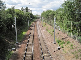
English: Langloan railway station (site), Lanarkshire Opened in 1866 by the Caledonian Railway on what is today the line from Glasgow to Whifflet, this station closed to passengers in 1966. View west towards Kirkwood and Glasgow. The main station building used to be to the right. When the line was reopened to passengers in 1993, Kirkwood (just visible in the distance) effectively replaced Langloan. Electrification of the line was taking place at the time this image was taken. |
| Date | |
| Source | From geograph.org.uk |
| Author | Nigel Thompson |
| Permission (Reusing this file) |
Creative Commons Attribution Share-alike license 2.0 |
| Attribution (required by the license) | Nigel Thompson / Langloan railway station (site), Lanarkshire / |
| Camera location | | View this and other nearby images on: OpenStreetMap |
|---|
,_Lanarkshire_(geograph_4060770).jpg¶ms=055.854201_N_-004.042168_E_globe:Earth_type:camera_source:geograph-osgb36(NS72266422)_heading:270.00&language=en)
| Object location | | View this and other nearby images on: OpenStreetMap |
|---|
,_Lanarkshire_(geograph_4060770).jpg¶ms=055.854190_N_-004.042970_E_globe:Earth_class:object_type:object_source:geograph-osgb36(NS72216422)_heading:270.00&language=en)
Licensing

|
This image was taken from the Geograph project collection. See this photograph's page on the Geograph website for the photographer's contact details. The copyright on this image is owned by Nigel Thompson and is licensed for reuse under the Creative Commons Attribution-ShareAlike 2.0 license.
|
This file is licensed under the Creative Commons Attribution-Share Alike 2.0 Generic license.
Attribution: Nigel Thompson
- You are free:
- to share – to copy, distribute and transmit the work
- to remix – to adapt the work
- Under the following conditions:
- attribution – You must give appropriate credit, provide a link to the license, and indicate if changes were made. You may do so in any reasonable manner, but not in any way that suggests the licensor endorses you or your use.
- share alike – If you remix, transform, or build upon the material, you must distribute your contributions under the same or compatible license as the original.
File history
Click on a date/time to view the file as it appeared at that time.
| Date/Time | Thumbnail | Dimensions | User | Comment | |
|---|---|---|---|---|---|
| current | 12:58, 5 January 2020 | | 1,024 × 768 (269 KB) | Lamberhurst | Transferred from geograph.co.uk using [https://tools.wmflabs.org/geograph2commons/ geograph2commons] |
File usage
The following pages on the English Wikipedia use this file (pages on other projects are not listed):
,_Lanarkshire_(geograph_4060770).jpg)