
File:Last scan of Typhoon Mawar on PGUA.jpg

Size of this preview: 800 × 393 pixels. Other resolutions: 320 × 157 pixels | 640 × 314 pixels | 1,024 × 503 pixels | 1,920 × 943 pixels.
Original file (1,920 × 943 pixels, file size: 580 KB, MIME type: image/jpeg)
| This is a file from the Wikimedia Commons. Information from its description page there is shown below. Commons is a freely licensed media file repository. You can help. |
Summary
| Description |
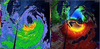
English: The last NEXRAD radar scans of Typhoon Mawar on PGUA. The left side shows NEXRAD reflectivity and the right side shows NEXRAD velocity. |
| Date | |
| Source | NEXRAD - PGUA |
| Author | National Weather Service |
Licensing
This image is in the public domain because it is from one or more of the U.S. government’s 159 NEXRAD radars, which are jointly owned and operated by the National Weather Service (NWS), an agency of the National Oceanic and Atmospheric Administration (NOAA) within the United States Department of Commerce, the Federal Aviation Administration (FAA) within the Department of Transportation, and the U.S. Air Force within the Department of Defense.
Thus all NEXRAD images are public domain.
|
  |
File history
Click on a date/time to view the file as it appeared at that time.
| Date/Time | Thumbnail | Dimensions | User | Comment | |
|---|---|---|---|---|---|
| current | 04:20, 24 May 2023 | | 1,920 × 943 (580 KB) | WeatherWriter | Uploaded a work by National Weather Service from NEXRAD - PGUA with UploadWizard |
File usage
The following pages on the English Wikipedia use this file (pages on other projects are not listed):
Global file usage
The following other wikis use this file:
- Usage on pt.wikipedia.org
- Usage on pt.wikinews.org
- Usage on zh.wikipedia.org