
File:Low Point Lighthouse Plan.jpg
No higher resolution available.
Low_Point_Lighthouse_Plan.jpg (357 × 480 pixels, file size: 38 KB, MIME type: image/jpeg)
| This is a file from the Wikimedia Commons. Information from its description page there is shown below. Commons is a freely licensed media file repository. You can help. |
Summary
| Camera location | | View this and other nearby images on: OpenStreetMap |
|---|
| Description |
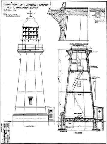
English: This is a construction plan for the concrete tower and iron light of the existing Low Point Lighthouse in New Victoria, Nova Scotia. This plan was produced by the Department of Transport Canada, Aids to Navigation Branch, in 1937 or earlier. This Lighthouse tower was completed in 1938, using the iron light from an earlier tower on the same site. |
| Date | |
| Source | Unknown (I've had the file on my computer for a number of years. I don't remember where I got it and I can't find it any longer online.) |
| Author | Department of Transport Canada, Aids to Navigation Branch, 1937 or earlier. |
Licensing
This Canadian work is in the public domain in Canada because its copyright has expired due to one of the following:
it was not subject to Crown copyright, and
|
 |
This media file is in the public domain in the United States. This applies to U.S. works where the copyright has expired, often because its first publication occurred prior to January 1, 1929, and if not then due to lack of notice or renewal. See this page for further explanation.
|
 | |
 |
This image might not be in the public domain outside of the United States; this especially applies in the countries and areas that do not apply the rule of the shorter term for US works, such as Canada, Mainland China (not Hong Kong or Macao), Germany, Mexico, and Switzerland. The creator and year of publication are essential information and must be provided. See Wikipedia:Public domain and Wikipedia:Copyrights for more details.
|
File history
Click on a date/time to view the file as it appeared at that time.
| Date/Time | Thumbnail | Dimensions | User | Comment | |
|---|---|---|---|---|---|
| current | 15:11, 9 May 2012 | | 357 × 480 (38 KB) | Ken Heaton |
File usage
The following pages on the English Wikipedia use this file (pages on other projects are not listed):
Global file usage
The following other wikis use this file:
- Usage on fr.wikipedia.org
- Usage on ru.wikipedia.org
- Usage on www.wikidata.org