
File:MN-districts-natat.JPG
No higher resolution available.
MN-districts-natat.JPG (590 × 458 pixels, file size: 45 KB, MIME type: image/jpeg)
| This is a file from the Wikimedia Commons. Information from its description page there is shown below. Commons is a freely licensed media file repository. You can help. |
Summary
| Description |
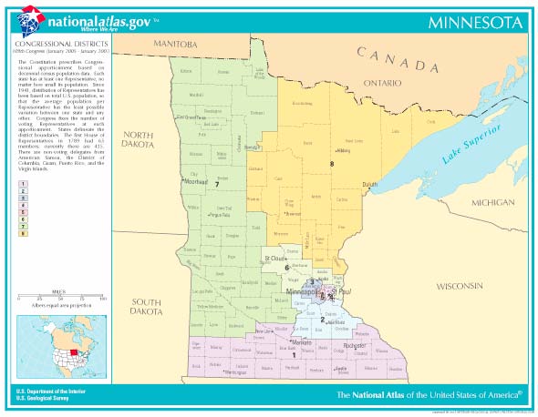
English: National Atlas map of Minnesota congressional districts |
| Source | From www.nationalatlas.gov |
| Author | National Atlas |
Licensing
This map was obtained from an edition of the National Atlas of the United States. Like almost all works of the U.S. federal government, works from the National Atlas are in the public domain in the United States.
Online access: NationalAtlas.gov | 1970 print edition: Library of Congress, Perry-Castañeda Library
|
Original upload log
Transferred from en.wikipedia to Commons by Innotata using CommonsHelper.
The original description page was here. All following user names refer to en.wikipedia.
- 2007-01-04 16:17 Appraiser 590×458× (46162 bytes) from www.nationalatlas.gov
File history
Click on a date/time to view the file as it appeared at that time.
| Date/Time | Thumbnail | Dimensions | User | Comment | |
|---|---|---|---|---|---|
| current | 21:02, 22 January 2011 | | 590 × 458 (45 KB) | File Upload Bot (Magnus Manske) | {{BotMoveToCommons|en.wikipedia|year={{subst:CURRENTYEAR}}|month={{subst:CURRENTMONTHNAME}}|day={{subst:CURRENTDAY}}}} {{Information |Description={{en|from www.nationalatlas.gov en:Category:Minnesota maps}} |Source=Transferred from [http://en.wiki |
File usage
The following pages on the English Wikipedia use this file (pages on other projects are not listed):