
File:Madison-Janesville-Beloit CSA.png
No higher resolution available.
Madison-Janesville-Beloit_CSA.png (434 × 459 pixels, file size: 14 KB, MIME type: image/png)
| This is a file from the Wikimedia Commons. Information from its description page there is shown below. Commons is a freely licensed media file repository. You can help. |
Summary
| Description |
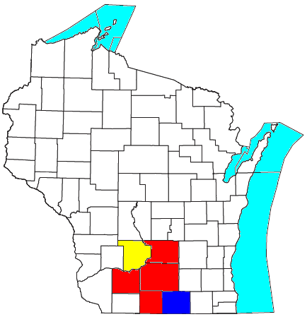
Map of Madison-Janesville-Beloit, WI Combined Statistical Area (CSA):
|
| Date | |
| Source | I modified File:Madison-Baraboo CSA.png, which was previously modified this United States Census Bureau file by Nyttend. |
| Author | Yassie |
| Permission (Reusing this file) |
US Government work is in public domain, and Nyttend has released his/her work into the public domain, too. I hereby release my work into public domain, too. |
Licensing
| I, the copyright holder of this work, release this work into the public domain. This applies worldwide. In some countries this may not be legally possible; if so: I grant anyone the right to use this work for any purpose, without any conditions, unless such conditions are required by law. |
File history
Click on a date/time to view the file as it appeared at that time.
| Date/Time | Thumbnail | Dimensions | User | Comment | |
|---|---|---|---|---|---|
| current | 16:07, 5 November 2014 | | 434 × 459 (14 KB) | Yassie | {{Information |Description= Map of Madison-Janesville-Beloit, WI Combined Statistical Area (CSA): * Red: Madison, WI MSA * Blue: Janesville-Beloit, WI MSA * Yellow: Baraboo, WI μSA |Source= I modified File:File:Madison-Baraboo CSA.png, which was... |
File usage
The following pages on the English Wikipedia use this file (pages on other projects are not listed):
Global file usage
The following other wikis use this file:
- Usage on www.wikidata.org