
File:Madoc Station.jpg
No higher resolution available.
Madoc_Station.jpg (576 × 379 pixels, file size: 97 KB, MIME type: image/jpeg)
| This is a file from the Wikimedia Commons. Information from its description page there is shown below. Commons is a freely licensed media file repository. You can help. |
Summary
| Description |
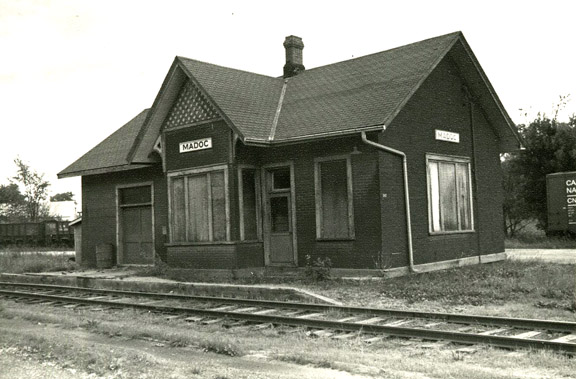
English: This image shows Madoc Station on the Belleville and North Hastings Railway, looking from the southwest towards northeast. The station was located just north of St. Lawrence Street on the western side of Madoc, Ontario.
The photographer, David Woodhead, took this image some time around 1974, shortly before the station burned down. It is already abandoned at this point. The switchyard can be seen behind the station, with some CN cars on it. The area has since been redeveloped as the Center Hastings Fire Department and the switchyard holds a helicopter landing pad, along with ample empty space. |
| Date | circa 1974 |
| Source | David Woodhead (in email) |
| Author | David Woodhead |
| Permission (Reusing this file) |
| Camera location | | View this and other nearby images on: OpenStreetMap |
|---|
Licensing
This file is licensed under the Creative Commons Attribution 2.5 Generic license.
- You are free:
- to share – to copy, distribute and transmit the work
- to remix – to adapt the work
- Under the following conditions:
- attribution – You must give appropriate credit, provide a link to the license, and indicate if changes were made. You may do so in any reasonable manner, but not in any way that suggests the licensor endorses you or your use.
File history
Click on a date/time to view the file as it appeared at that time.
| Date/Time | Thumbnail | Dimensions | User | Comment | |
|---|---|---|---|---|---|
| current | 20:31, 7 October 2013 | | 576 × 379 (97 KB) | Maury Markowitz | User created page with UploadWizard |
File usage
The following pages on the English Wikipedia use this file (pages on other projects are not listed):