
File:Map of I-95 discontinuity in NJ.svg

Original file (SVG file, nominally 780 × 761 pixels, file size: 29 KB)
| This is a file from the Wikimedia Commons. Information from its description page there is shown below. Commons is a freely licensed media file repository. You can help. |
Summary
| Description |
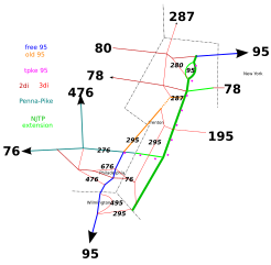
This is a map of all the w:Interstate highways in w:New Jersey, w:Delaware, and some in the w:Philadelphia area, as well as w:NJTP. Its main purpose is to illustrate the w:I-95 disconectivity there, as well as NJTP's role. Not to scale. It is color-coded.
See the image for color-coding. The dotted pink line represents the future alignment of I-95 along the w:Pennsylvania Turnpike and the NJTP. The entire NJTP portion is already designated; however, the part south of w:I-287 is not fully signed yet. The Pennsylvania part is currently w:I-276. The orange represents the old route. of I-95. Going from south to north, there are three segments. The first is the only one that is still I-95, but plans are in place to make it w:Interstate 295 (Delaware-New Jersey-Pennsylvania). The dotted part is the never=built w:Somorset Freeway. The northernmost part may have been I-95 at some point, but today it is clearly the southernmost part of I-287. The blue marks a free section of I-95 that is not involved in this mess.
|
| Date | |
| Source | I made this myself using w:Inkscape shortly prior to uploading. |
| Author | Engleman~commonswiki |
| Other versions | I uploaded a PNG version, because this rendering is weird; Image:Map of I-95 discontinuity in NJ.png. |
Licensing

|
Permission is granted to copy, distribute and/or modify this document under the terms of the GNU Free Documentation License, Version 1.2 or any later version published by the Free Software Foundation; with no Invariant Sections, no Front-Cover Texts, and no Back-Cover Texts. A copy of the license is included in the section entitled GNU Free Documentation License. |
| This file is licensed under the Creative Commons Attribution-Share Alike 3.0 Unported license. | ||
| ||
| This licensing tag was added to this file as part of the GFDL licensing update. |
- You are free:
- to share – to copy, distribute and transmit the work
- to remix – to adapt the work
- Under the following conditions:
- attribution – You must give appropriate credit, provide a link to the license, and indicate if changes were made. You may do so in any reasonable manner, but not in any way that suggests the licensor endorses you or your use.
- share alike – If you remix, transform, or build upon the material, you must distribute your contributions under the same or compatible license as the original.
File history
Click on a date/time to view the file as it appeared at that time.
| Date/Time | Thumbnail | Dimensions | User | Comment | |
|---|---|---|---|---|---|
| current | 01:29, 26 October 2012 | | 780 × 761 (29 KB) | AnonMoos | adjust margins |
| 02:43, 3 November 2005 |  | 744 × 1,052 (29 KB) | Engleman~commonswiki | improvements over previous revision; will go into detail soon | |
| 02:56, 1 November 2005 |  | 744 × 1,052 (27 KB) | Engleman~commonswiki | Not to scale. It is a color-coded map of the strange situation with I-95 through New Jersey and Pennsylvana, largely caused by the NJTP, but directly caused by the lack of the Somorset freeway. I made this myself using w:Inkscape. I will also probably |