
File:Map of Lewis and Clark's Track, Across the Western Portion of North America, published 1814.png
Original file (7,000 × 3,043 pixels, file size: 2.87 MB, MIME type: image/png)
| This is a file from the Wikimedia Commons. Information from its description page there is shown below. Commons is a freely licensed media file repository. You can help. |
Summary
NOTE: This is a conversion from a 256-color JPEG version of the file. This one has adjusted levels for improved clarity, and formatting changes to reduce file size by over 70%. -Peteforsyth 05:59, 11 September 2007 (UTC)
Author: Lewis, Meriwether ; Clark, William ; Biddle, Nicholas ; Allen, Paul
Date: 1814
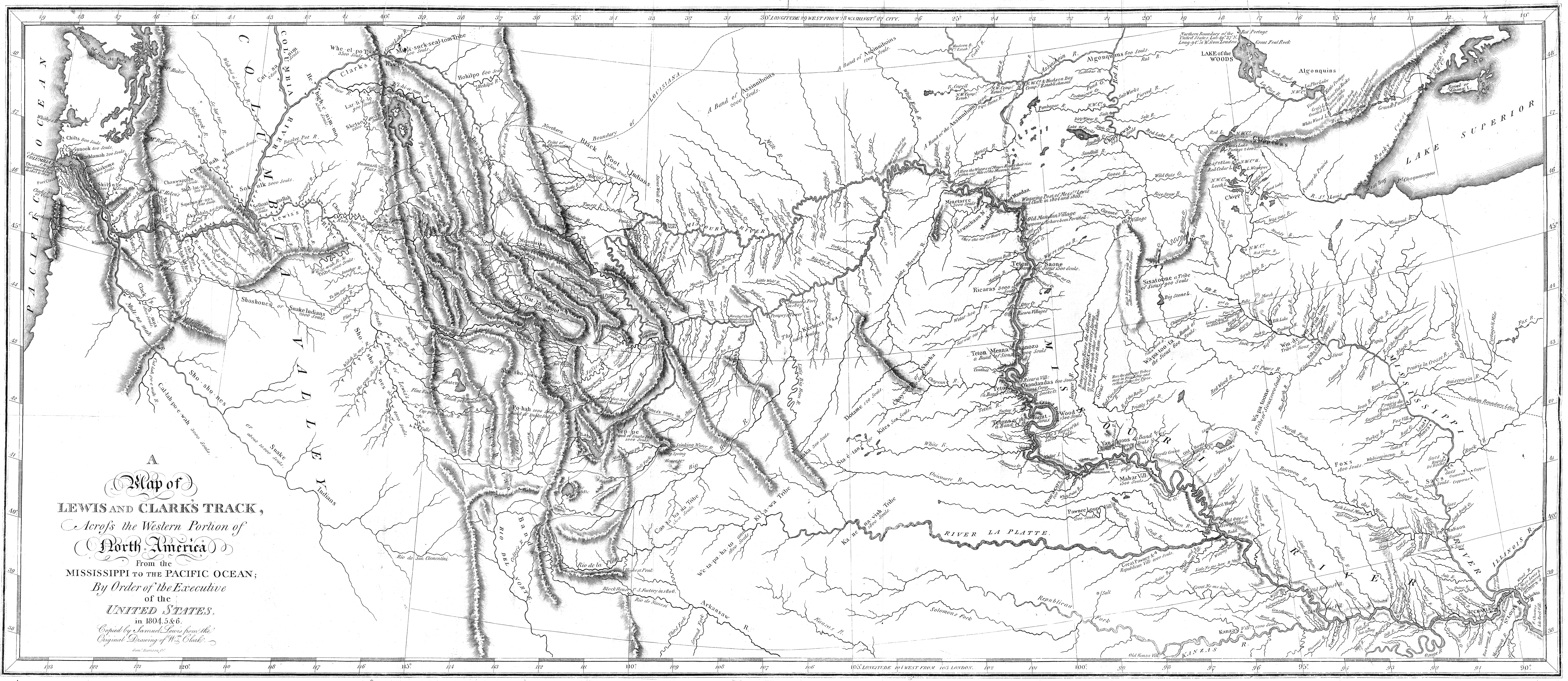
Short Title: Map of Lewis and Clark's Track, Across the Western Portion of North America.
Publisher: Philadelphia: Bradford and Inskeep
Type: Book Map
Obj Height cm: 30
Obj Width cm: 70
Scale 1: 4,300,000
Note: Uncolored map showing topography and rivers in the region as well as towns, Indian villages, and population figures. Bound into the front of volume one.
Reference: Howes L317; Sabin 40828; WC 13; Wheat 316.
State/Province: U.S. West
Full Title: A Map of Lewis and Clark's Track, Across the Western Portion of North America From the Mississippi to the Pacific Ocean; By Order of the Executive of the United States, in 1804, 5 & 6. Copied by Samuel Lewis from the Original Drawing of Wm. Clark. Smal. Harrison fct.
List No: 3493.001
Series No: 2
Engraver or Printer: Lewis, Samuel ; Harrison, Samuel, 1789-1818
Publication Author: Lewis, Meriwether ; Clark, William ; Biddle, Nicholas ; Allen, Paul
Pub Date: 1814
Pub Title: History Of The Expedition Under The Command Of Captains Lewis And Clark, To The Sources Of The Missouri, Thence Across The Rocky Mountains And Down The River Columbia To The Pacific Ocean. Performed During The Years 1804-5-6. By order of the Government Of The United States. Prepared For The Press By Paul Allen, Esquire. In Two Volumes. Vol. I. Philadelphia: Published By Bradford And Inskeep, New York. J. Maxwell, Printer. 1814 ... Vol. II.
Pub Reference: Howes L317; Sabin 40828; WC 13; Wheat 316.
Pub Note: 1st edition. Notwithstanding the title, Nicholas Biddle completed the text after Lewis's suicide. The map and the written account of the expedition changed American mapping of the northwest by giving the first accurate depiction of the relationship of the sources of the Missouri, the sources of the Columbia, and the Rocky Mountains. The map was copied by Samuel Lewis from William Clark's original drawing, and was engraved by Samuel Harrison. The title of the map is "A Map of Lewis and Clark's Track, Across the Western Portion of North America From the Mississippi to the Pacific Ocean ..." Maps are without color. In 2 volumes newly bound in full leather with the title "Lewis & Clark's Expedition ..." stamped in gilt on the spine.
Pub List No: 3493.000
Pub Type: Exploration Book
Pub Maps: 6
Pub Height cm: 23
Pub Width cm: 14
Licensing
The author died in 1844, so this work is in the public domain in its country of origin and other countries and areas where the copyright term is the author's life plus 100 years or fewer. | |
| This file has been identified as being free of known restrictions under copyright law, including all related and neighboring rights. | |
File history
Click on a date/time to view the file as it appeared at that time.
| Date/Time | Thumbnail | Dimensions | User | Comment | |
|---|---|---|---|---|---|
| current | 05:59, 11 September 2007 | | 7,000 × 3,043 (2.87 MB) | Peteforsyth | == Summary == NOTE: This is a conversion from a 256-color JPEG version of the file. This one has adjusted levels for improved clarity, and formatting changes to reduce file size by over 70%. -~~~~ Author: Lewis, Meriwether ; Clark, William ; Biddle, Nich |