
File:Map of South Africa with English labels.svg

Size of this PNG preview of this SVG file: 684 × 599 pixels. Other resolutions: 274 × 240 pixels | 548 × 480 pixels | 876 × 768 pixels | 1,168 × 1,024 pixels | 2,337 × 2,048 pixels | 809 × 709 pixels.
Original file (SVG file, nominally 809 × 709 pixels, file size: 540 KB)
| This is a file from the Wikimedia Commons. Information from its description page there is shown below. Commons is a freely licensed media file repository. You can help. |
W3C-validity not checked.
Summary
| Description |
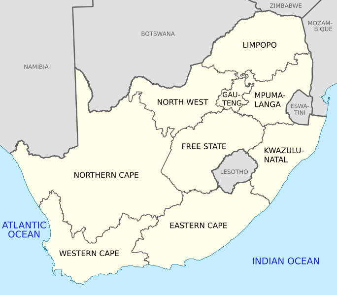
English: Map of South Africa, with provinces, neighbouring countries and oceans labelled in English. Based on File:Map of South Africa with provincial borders.svg. |
| Date | |
| Source | Own work |
| Author | Htonl |
| Other versions |
Licensing
I, the copyright holder of this work, hereby publish it under the following licenses:
This file is licensed under the Creative Commons Attribution-Share Alike 4.0 International and 3.0 Unported license.
- You are free:
- to share – to copy, distribute and transmit the work
- to remix – to adapt the work
- Under the following conditions:
- attribution – You must give appropriate credit, provide a link to the license, and indicate if changes were made. You may do so in any reasonable manner, but not in any way that suggests the licensor endorses you or your use.
- share alike – If you remix, transform, or build upon the material, you must distribute your contributions under the same or compatible license as the original.

|
Permission is granted to copy, distribute and/or modify this document under the terms of the GNU Free Documentation License, Version 1.2 or any later version published by the Free Software Foundation; with no Invariant Sections, no Front-Cover Texts, and no Back-Cover Texts. A copy of the license is included in the section entitled GNU Free Documentation License. |
If this file is eligible for relicensing, it may also be used under the Creative Commons Attribution-ShareAlike 3.0 license. The relicensing status of this image has not yet been reviewed. You can help.
|
You may select the license of your choice.
File history
Click on a date/time to view the file as it appeared at that time.
| Date/Time | Thumbnail | Dimensions | User | Comment | |
|---|---|---|---|---|---|
| current | 10:39, 24 May 2021 | | 809 × 709 (540 KB) | Htonl | Eswatini label |
| 20:50, 22 April 2011 |  | 809 × 709 (541 KB) | Htonl | tweak size, labels | |
| 23:11, 29 November 2010 |  | 757 × 660 (349 KB) | Htonl | style | |
| 13:45, 5 October 2010 |  | 1,071 × 934 (288 KB) | Htonl | tweak | |
| 06:24, 5 October 2010 |  | 1,071 × 934 (445 KB) | Htonl | Use Lambert conformal projection | |
| 14:30, 4 April 2010 |  | 1,000 × 786 (415 KB) | Htonl | wrong language! | |
| 14:27, 4 April 2010 |  | 1,000 × 786 (414 KB) | Htonl | cleaner lines | |
| 22:18, 25 January 2010 |  | 1,000 × 786 (155 KB) | Htonl | and again | |
| 22:08, 25 January 2010 |  | 1,000 × 786 (220 KB) | Htonl | try again | |
| 21:51, 25 January 2010 |  | 1,000 × 786 (155 KB) | Htonl | changed GP/NW border |
File usage
The following pages on the English Wikipedia use this file (pages on other projects are not listed):
- Administrative divisions of South Africa
- Domestic violence in South Africa
- Education in South Africa
- Federation
- HIV/AIDS in South African townships
- List of etymologies of administrative divisions
- Politics of country subdivisions
- Sexual violence in South Africa
- South Africa
- Talk:South Africa/Archive 5
Global file usage
The following other wikis use this file:
- Usage on als.wikipedia.org
- Usage on azb.wikipedia.org
- Usage on be.wikipedia.org
- Usage on cy.wikipedia.org
- Usage on dsb.wikipedia.org
- Usage on el.wikipedia.org
- Usage on en.wikiquote.org
- Usage on fi.wikipedia.org
- Usage on fr.wikipedia.org
- Usage on fy.wikipedia.org
- Usage on gl.wikipedia.org
- Usage on hr.wikipedia.org
- Usage on is.wikipedia.org
- Usage on ka.wikipedia.org
- Usage on ml.wikipedia.org
- Usage on ms.wikipedia.org
- Usage on nso.wikipedia.org
- Usage on pdc.wikipedia.org
- Usage on rm.wikipedia.org
- Usage on ro.wikipedia.org
- Usage on sco.wikipedia.org
- Usage on sh.wikipedia.org
- Usage on simple.wikipedia.org
- Usage on so.wikipedia.org
- Usage on sr.wikipedia.org
- Usage on sv.wikipedia.org
- Usage on ta.wikipedia.org
- Usage on th.wikipedia.org
- Usage on tn.wikipedia.org
- Usage on tr.wikipedia.org
- Usage on tum.wikipedia.org
- Usage on uk.wikipedia.org
- Usage on yo.wikipedia.org
- Usage on zh-min-nan.wikipedia.org
- Usage on zh.wikipedia.org