
File:Map of Sweden, CIA, 1996.jpg

Original file (2,036 × 2,484 pixels, file size: 2.77 MB, MIME type: image/jpeg)
| This is a file from the Wikimedia Commons. Information from its description page there is shown below. Commons is a freely licensed media file repository. You can help. |
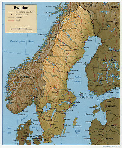
Sweden.
United States. Central Intelligence Agency.
CREATED/PUBLISHED [Washington, D.C. : Central Intelligence Agency, 1996]
NOTES Relief shown by shading.
"Base 802435 (A04937) 2-96."
Also issued without shaded relief.
Scale [ca. 1:7,750,000] ; Lambert conformal conic proj. (E 100--E 250/N 700--N 550).
SUBJECTS Sweden--Maps. Sweden--Maps, Physical. Sweden.
MEDIUM 1 map : col. ; 21 x 17 cm.
CALL NUMBER G6950 1996 .U6
REPOSITORY Library of Congress Geography and Map Division Washington, D.C. 20540-4650 USA
DIGITAL ID g6950 ct001017 http://hdl.loc.gov/loc.gmd/g6950.ct001017
| This image is a work of a Central Intelligence Agency employee, taken or made as part of that person's official duties. As a Work of the United States Government, this image or media is in the public domain in the United States.
|

|
File history
Click on a date/time to view the file as it appeared at that time.
| Date/Time | Thumbnail | Dimensions | User | Comment | |
|---|---|---|---|---|---|
| current | 19:59, 3 March 2006 | | 2,036 × 2,484 (2.77 MB) | Brian0918 | Sweden. United States. Central Intelligence Agency. CREATED/PUBLISHED [Washington, D.C. : Central Intelligence Agency, 1996] NOTES Relief shown by shading. "Base 802435 (A04937) 2-96." Also issued without shaded relief. Scale [ca. 1:7,750,000] ; Lam |
File usage
Global file usage
The following other wikis use this file:
- Usage on cs.wikipedia.org
- Usage on de.wikipedia.org
- Usage on es.wikipedia.org
- Usage on it.wikipedia.org
- Usage on sr.wikipedia.org
- Usage on sv.wikipedia.org
- Usage on th.wikipedia.org
- Usage on uk.wikipedia.org