
File:Map of United States vivid colors shown.png
No higher resolution available.
Map_of_United_States_vivid_colors_shown.png (800 × 495 pixels, file size: 187 KB, MIME type: image/png)
| This is a file from the Wikimedia Commons. Information from its description page there is shown below. Commons is a freely licensed media file repository. You can help. |
Summary
| Description |
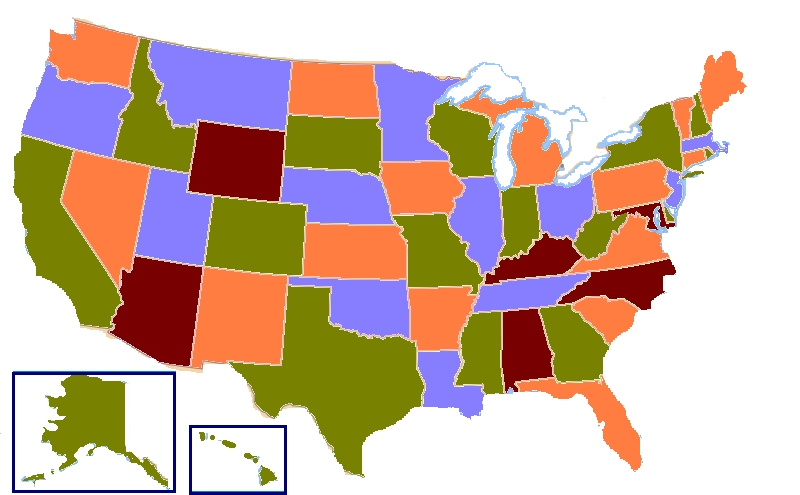
English: A map of the United States showing four colors. According to the four color theorem, only four colors are needed to complete a map containing any type of shapes provided that two touching shapes share a border of at least two points (a line). |
| Date | (UTC) |
| Source | |
| Author |
|

|
File:Map of United States vivid colors shown.svg is a vector version of this file. It should be used in place of this PNG file when not inferior.
File:Map of United States vivid colors shown.png → File:Map of United States vivid colors shown.svg
For more information, see Help:SVG. |
 |
| This is a retouched picture, which means that it has been digitally altered from its original version. Modifications: Added brighter colors, removed extraneous detail, added boxes around Hawaii & Alaska. The original can be viewed here: Map of USA four colours.svg:
|
Licensing
This file is licensed under the Creative Commons Attribution-Share Alike 3.0 Unported license.
- You are free:
- to share – to copy, distribute and transmit the work
- to remix – to adapt the work
- Under the following conditions:
- attribution – You must give appropriate credit, provide a link to the license, and indicate if changes were made. You may do so in any reasonable manner, but not in any way that suggests the licensor endorses you or your use.
- share alike – If you remix, transform, or build upon the material, you must distribute your contributions under the same or compatible license as the original.
Original upload log
This image is a derivative work of the following images:
- File:Map_of_USA_four_colours.svg licensed cc-by-sa-3.0
File history
Click on a date/time to view the file as it appeared at that time.
| Date/Time | Thumbnail | Dimensions | User | Comment | |
|---|---|---|---|---|---|
| current | 08:37, 18 November 2015 | | 800 × 495 (187 KB) | Trotting cove | cleanup dots and lakes |
| 13:15, 19 April 2012 |  | 800 × 495 (146 KB) | Tomwsulcer | {{Information |Description= A map of the United States showing four colors. According to the four color theorem, only four colors are needed to complete a map containing any type of shapes provided that two touching shapes share a border of at least tw... |
File usage
The following pages on the English Wikipedia use this file (pages on other projects are not listed):
Global file usage
The following other wikis use this file:
- Usage on ca.wikipedia.org
- Usage on ckb.wikipedia.org
- Usage on cy.wikipedia.org
- Usage on el.wikipedia.org
- Usage on es.wikipedia.org
- Usage on hy.wikipedia.org
- Usage on id.wikipedia.org
- Usage on sr.wikipedia.org
- Usage on zh.wikipedia.org