
File:Map of south essex 1594 John Norden.jpg

Size of this preview: 800 × 558 pixels. Other resolutions: 320 × 223 pixels | 640 × 446 pixels | 1,024 × 714 pixels | 1,293 × 902 pixels.
Original file (1,293 × 902 pixels, file size: 899 KB, MIME type: image/jpeg)
| This is a file from the Wikimedia Commons. Information from its description page there is shown below. Commons is a freely licensed media file repository. You can help. |
Summary
| Description |
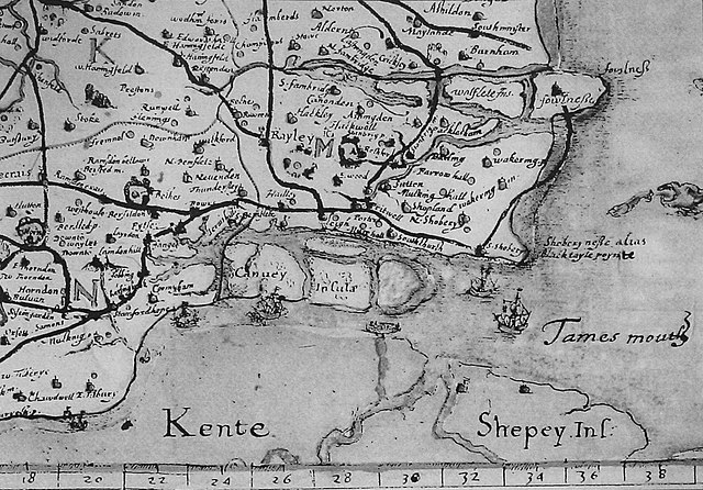
English: Image of John Norden's map of south east essex in 1594. The map shows the geographical status of the Canvey group of islands before the unifying reclamation project of 1622. |
| Date | |
| Source | John Norden. (1594). Speculi Brinanniæ Pars: an Historical and Chorographical Description of the County of Essex. First published in 1840 by the Camden Society, London. |
| Author | John Norden |
Licensing
|
This work is in the public domain in its country of origin and other countries and areas where the copyright term is the author's life plus 100 years or fewer. | |
| This file has been identified as being free of known restrictions under copyright law, including all related and neighboring rights. | |
File history
Click on a date/time to view the file as it appeared at that time.
| Date/Time | Thumbnail | Dimensions | User | Comment | |
|---|---|---|---|---|---|
| current | 11:29, 3 June 2008 | | 1,293 × 902 (899 KB) | Oneblackline | {{Information |Description={{en|1=Image of John Norden's map of south east essex in 1594. The map shows the geographical status of the Canvey group of islands before the unifying reclamation project of 1622.}} |Source=John Norden. (1594). Speculi Brinanni |
File usage
The following pages on the English Wikipedia use this file (pages on other projects are not listed):
Global file usage
The following other wikis use this file:
- Usage on ar.wikipedia.org
- Usage on azb.wikipedia.org
- Usage on fa.wikipedia.org
- Usage on ru.wikipedia.org
- Usage on uk.wikipedia.org