
File:Map of the Erivan Khanate in 1820.svg

Size of this PNG preview of this SVG file: 800 × 467 pixels. Other resolutions: 320 × 187 pixels | 640 × 374 pixels | 1,024 × 598 pixels | 1,280 × 747 pixels | 2,560 × 1,494 pixels | 3,748 × 2,188 pixels.
Original file (SVG file, nominally 3,748 × 2,188 pixels, file size: 2.11 MB)
| This is a file from the Wikimedia Commons. Information from its description page there is shown below. Commons is a freely licensed media file repository. You can help. |
Summary
Summary
| Description |
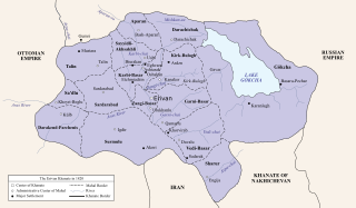
English: Map of the Iran-ruled Erivan Khanate in 1820. |
| Date | |
| Source |
|
| Author | HistoryofIran |
Licensing
I, the copyright holder of this work, hereby publish it under the following license:
This file is licensed under the Creative Commons Attribution-Share Alike 4.0 International license.
- You are free:
- to share – to copy, distribute and transmit the work
- to remix – to adapt the work
- Under the following conditions:
- attribution – You must give appropriate credit, provide a link to the license, and indicate if changes were made. You may do so in any reasonable manner, but not in any way that suggests the licensor endorses you or your use.
- share alike – If you remix, transform, or build upon the material, you must distribute your contributions under the same or compatible license as the original.
File history
Click on a date/time to view the file as it appeared at that time.
| Date/Time | Thumbnail | Dimensions | User | Comment | |
|---|---|---|---|---|---|
| current | 23:17, 6 May 2024 | | 3,748 × 2,188 (2.11 MB) | HistoryofIran | =={{int:filedesc}}== {{Information |description={{en|1=Map of the Erivan Khanate, a province of Iran.}} |date=2024-05-07 |source=* Based on the map in Bournoutian, George (1992). The Khanate of Erevan Under Qajar Rule: 1795-1828, page 25 * Created the Nakhichevan Khanate through Bournoutian, George (1994). A History of Qarabagh: An Annotated Translation of Mirza Jamal Javanshir Qarabaghi's Tarikh-e Qarabagh, page 25 * Created the Russia border through Tsutsiev, Arthur (2014). Atlas of the Eth... |
File usage
The following pages on the English Wikipedia use this file (pages on other projects are not listed):