File:Map of the Gulf, Colorado and Santa Fe 'Texas Midland Route' 1880 UTA.jpg

Page contents not supported in other languages.
This is a file from the Wikimedia Commons
From Wikipedia, the free encyclopedia

Original file(9,230 × 8,592 pixels, file size: 13.64 MB, MIME type: image/jpeg)

Summary

Warning The original file is very high-resolution. It might not load properly or could cause your browser to freeze when opened at full size.
Title
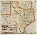
English: Gulf, Colorado and Santa Fe Railway and Connections. The "Texas Midland Route".
Description
English: This promotional map of Texas, Indian Territory, and parts of surrounding states is quite unusual in its almost fluorescent coloration. The text on the back of the map advertises "300 miles of track" and "better and surer connections" with trains of the International and Great Northern Railroad. Since the G.C. & S.F. wanted to promote this relationship, the map shows those lines thicker, although not as thick as the G.C.& S.F. itself. Not surprisingly, the thinner lines are reserved for the main competitor railroad: the Houston & Texas Central.
Date circa 1880
date QS:P,+1880-00-00T00:00:00Z/9,P1480,Q5727902
Source UTA Libraries Cartographic Connections: map / text
Creator
Woodward, Tiernan & Hale et al.
Credit line
English: The University of Texas at Arlington Libraries Special Collections
 Geotemporal data
Map location Texas
Georeferencing Georeference the map in Wikimaps Warper If inappropriate please set warp_status = skip to hide.
 Bibliographic data
Place of publication Galveston
Publisher
Gulf, Colorado and Santa Fe Railway
Printed by
Woodward, Tiernan & Hale, St. Louis
 Archival data
institution QS:P195,Q1230739
Dimensions height: 47 cm (18.5 in); width: 51.5 cm (20.2 in)
dimensions QS:P2048,47U174728
dimensions QS:P2049,51.5U174728
Medium color cerograph
chromolithograph
medium QS:P186,Q1121337


Licensing

Public domain
This work was published before January 1, 1929 and it is anonymous or pseudonymous due to unknown authorship. It is in the public domain in the United States as well as countries and areas where the copyright terms of anonymous or pseudonymous works are 95 years or fewer since publication.

Captions

Add a one-line explanation of what this file represents

Items portrayed in this file

depicts

0.025 second

image/jpeg

File history

Click on a date/time to view the file as it appeared at that time.

Date/TimeThumbnailDimensionsUserComment
current18:15, 6 April 2022Thumbnail for version as of 18:15, 6 April 20229,230 × 8,592 (13.64 MB)Michael Barera== {{int:filedesc}} == {{Map |title = {{en|'''''Gulf, Colorado and Santa Fe Railway and Connections. The "Texas Midland Route".'''''}} |description = {{en|This promotional map of Texas, Indian Territory, and parts of surrounding states is quite unusual in its almost fluorescent coloration. The text on the back of the map advertises "300 miles of track" and "better and surer connections" with trains of the International and Great Northern Railroad. Since the G.C. & S.F. wan...
The following pages on the English Wikipedia use this file (pages on other projects are not listed):

Global file usage

The following other wikis use this file:

Metadata