
File:Map of the offshore wind power farms in the German Bight.png

Size of this preview: 747 × 599 pixels. Other resolutions: 299 × 240 pixels | 599 × 480 pixels | 958 × 768 pixels | 1,277 × 1,024 pixels | 2,553 × 2,048 pixels | 4,342 × 3,483 pixels.
Original file (4,342 × 3,483 pixels, file size: 2.6 MB, MIME type: image/png)
| This is a file from the Wikimedia Commons. Information from its description page there is shown below. Commons is a freely licensed media file repository. You can help. |
Summary
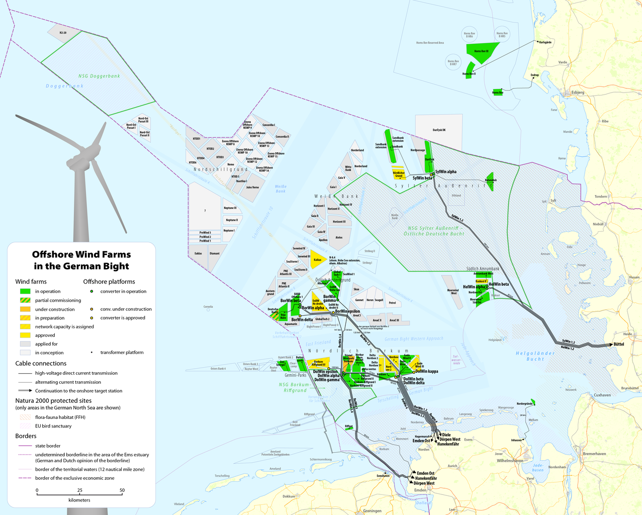
| Description |
Deutsch: Karte der Offshore-Windkraftanlagen in der Deutschen Bucht sowie deren Kabelanbindungen
English: Map of offshore wind farms and connecting power cables in the German Bight |
|||
| Date | see file history | |||
| Source |
Own work, using data and information from these web sites: |
|||
| Author | Maximilian Dörrbecker (Chumwa) | |||
| Permission (Reusing this file) |
This file is licensed under the Creative Commons Attribution-Share Alike 2.0 Generic license.
Sie dürfen das Bild zu den folgenden Bedingungen nutzen:
|
|||
| Other versions |
|


File history
Click on a date/time to view the file as it appeared at that time.
| Date/Time | Thumbnail | Dimensions | User | Comment | |
|---|---|---|---|---|---|
| current | 08:14, 13 June 2020 | | 4,342 × 3,483 (2.6 MB) | Chumwa | update |
| 20:25, 21 January 2020 |  | 4,342 × 3,483 (2.61 MB) | Chumwa | update | |
| 21:41, 4 September 2018 |  | 4,342 × 3,483 (2.6 MB) | Chumwa | update | |
| 15:13, 23 June 2018 |  | 4,342 × 3,483 (2.61 MB) | Chumwa | corr | |
| 14:47, 22 June 2018 |  | 4,342 × 3,483 (2.6 MB) | Chumwa | update | |
| 10:32, 6 January 2018 |  | 4,342 × 3,483 (2.53 MB) | Chumwa | update | |
| 20:12, 21 June 2017 |  | 4,342 × 3,483 (2.53 MB) | Chumwa | update | |
| 07:19, 7 May 2017 |  | 4,342 × 3,483 (2.53 MB) | Chumwa | ||
| 21:59, 28 April 2017 |  | 4,342 × 3,483 (2.53 MB) | Chumwa | update | |
| 07:43, 15 April 2017 |  | 4,342 × 3,483 (2.51 MB) | Chumwa | {{Information |Description= |Source={{own}} |Date= |Author= Chumwa |Permission= |other_versions= }} == {{int:filedesc}} == {{Information |Description = {{de|1=Karte der Offshore-Windkraftanlagen in der Deutschen Bucht sowie deren Kab... |
File usage
The following pages on the English Wikipedia use this file (pages on other projects are not listed):
Global file usage
The following other wikis use this file:
- Usage on de.wikipedia.org
- Usage on fr.wikipedia.org
- Usage on nl.wikipedia.org
- Usage on ru.wikipedia.org
- Usage on uz.wikipedia.org
- Usage on www.wikidata.org