
File:Massacre Canyon monument and marker.JPG

Size of this preview: 800 × 581 pixels. Other resolutions: 320 × 232 pixels | 640 × 464 pixels | 1,024 × 743 pixels | 1,280 × 929 pixels | 2,487 × 1,805 pixels.
Original file (2,487 × 1,805 pixels, file size: 1.67 MB, MIME type: image/jpeg)
| This is a file from the Wikimedia Commons. Information from its description page there is shown below. Commons is a freely licensed media file repository. You can help. |
Summary
| Description |
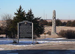
English: Massacre Canyon monument and historical marker on south side of U.S. Highway 34 northeast of Trenton, Nebraska; seen from the east. According to the historical marker, the monument was built in 1930. |
| Date | |
| Source | Own work |
| Author | Ammodramus |
| Camera location | | View this and other nearby images on: OpenStreetMap |
|---|
Licensing
| I, the copyright holder of this work, release this work into the public domain. This applies worldwide. In some countries this may not be legally possible; if so: I grant anyone the right to use this work for any purpose, without any conditions, unless such conditions are required by law. |
File history
Click on a date/time to view the file as it appeared at that time.
| Date/Time | Thumbnail | Dimensions | User | Comment | |
|---|---|---|---|---|---|
| current | 03:07, 20 January 2010 | | 2,487 × 1,805 (1.67 MB) | Ammodramus | {{Information |Description={{en|1=Massacre Canyon monument and historical marker on south side of {{w|U.S. Highway 34}} northeast of {{w|Trenton, Nebraska}}; seen from the east. According to the historical marker, the m |
File usage
The following pages on the English Wikipedia use this file (pages on other projects are not listed):
Global file usage
The following other wikis use this file:
- Usage on azb.wikipedia.org
- Usage on da.wikipedia.org
- Usage on fr.wikipedia.org
- Usage on tr.wikipedia.org