
File:MobileBroadbandInternetPenetrationWorldMap 2013.svg

Size of this PNG preview of this SVG file: 800 × 411 pixels. Other resolutions: 320 × 164 pixels | 640 × 329 pixels | 1,024 × 526 pixels | 1,280 × 657 pixels | 2,560 × 1,314 pixels | 863 × 443 pixels.
Original file (SVG file, nominally 863 × 443 pixels, file size: 1.54 MB)
| This is a file from the Wikimedia Commons. Information from its description page there is shown below. Commons is a freely licensed media file repository. You can help. |
Summary
| Description |
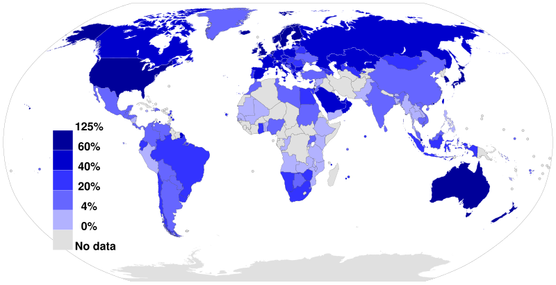
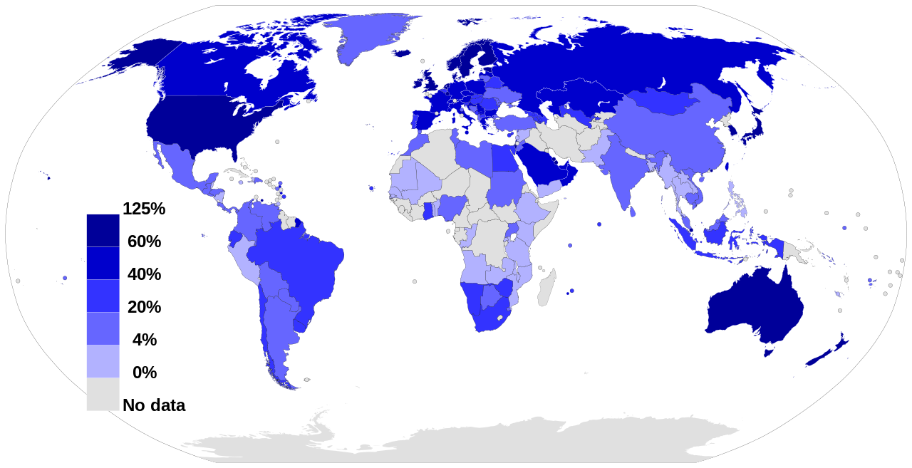
English: A world map colored to show the level of Mobile Broadband Internet penetration in 2012 (number of subscriptions as a percentage of a country's population). |
| Date | 7 July 2013, 13:54:35 |
| Source |
Own work, based on figures from the Wikipedia:List of countries by number of broadband Internet subscriptions article in the English Wikipedia, which is in turn based on figures from the International Telecommunications Union (ITU) for 2012. This vector image includes elements that have been taken or adapted from this file: |
| Author | Jeff Ogden (W163) |
| SVG development | This world map was created with a text editor. |
Licensing
Jeff Ogden (W163), the copyright holder of this work, hereby publishes it under the following license:
This file is licensed under the Creative Commons Attribution-Share Alike 3.0 Unported license.
Attribution: Jeff Ogden (W163)
- You are free:
- to share – to copy, distribute and transmit the work
- to remix – to adapt the work
- Under the following conditions:
- attribution – You must give appropriate credit, provide a link to the license, and indicate if changes were made. You may do so in any reasonable manner, but not in any way that suggests the licensor endorses you or your use.
- share alike – If you remix, transform, or build upon the material, you must distribute your contributions under the same or compatible license as the original.
File history
Click on a date/time to view the file as it appeared at that time.
| Date/Time | Thumbnail | Dimensions | User | Comment | |
|---|---|---|---|---|---|
| current | 20:44, 17 February 2022 | | 863 × 443 (1.54 MB) | Enyavar | Reverted to version as of 11:20, 2 February 2021 (UTC) dear Jamie Tubers, please don't insert 2020 data in a 2012 map without updating ALL countries |
| 16:32, 8 February 2021 |  | 863 × 443 (1.56 MB) | Jamie Tubers | Reverted to version as of 20:27, 22 July 2020 (UTC) | |
| 11:20, 2 February 2021 |  | 863 × 443 (1.54 MB) | Pieceofmetalwork | Reverted to version as of 17:58, 7 July 2013 (UTC) | |
| 20:27, 22 July 2020 |  | 863 × 443 (1.56 MB) | Jamie Tubers | update | |
| 17:58, 7 July 2013 |  | 863 × 443 (1.54 MB) | W163 | User created page with UploadWizard |
File usage
The following pages on the English Wikipedia use this file (pages on other projects are not listed):
Global file usage
The following other wikis use this file:
- Usage on ar.wikipedia.org
- Usage on ca.wikipedia.org
- Usage on el.wikipedia.org
- Usage on es.wikipedia.org
- Usage on fa.wikipedia.org
- Usage on id.wikipedia.org
- Usage on pnb.wikipedia.org
- Usage on th.wikipedia.org
- Usage on tr.wikipedia.org
- Usage on uk.wikipedia.org
- Usage on ur.wikipedia.org
- Usage on zh.wikipedia.org