
File:Mont-Avalanche Saint-Adolphe-d'Howard Quebec Canada.jpg

Size of this preview: 800 × 450 pixels. Other resolutions: 320 × 180 pixels | 640 × 360 pixels | 1,024 × 576 pixels | 1,280 × 720 pixels | 2,490 × 1,400 pixels.
Original file (2,490 × 1,400 pixels, file size: 879 KB, MIME type: image/jpeg)
| This is a file from the Wikimedia Commons. Information from its description page there is shown below. Commons is a freely licensed media file repository. You can help. |
Summary
| Description |
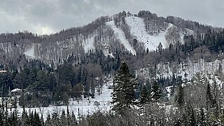
Français : Vue d'ensemble du Mont-Avalanche à Saint-Adolphe-d'Howard au Québec et montrant où se situe la station de ski
English: Global view of Mont-Avalanche in Saint-Adolphe-d'Howard, Quebec, showing where the ski resort is located |
| Date | |
| Source | Own work |
| Author | Nicolas Pellemans |
| Camera location | | View this and other nearby images on: OpenStreetMap |
|---|
Licensing
I, the copyright holder of this work, hereby publish it under the following license:
This file is licensed under the Creative Commons Attribution 4.0 International license.
- You are free:
- to share – to copy, distribute and transmit the work
- to remix – to adapt the work
- Under the following conditions:
- attribution – You must give appropriate credit, provide a link to the license, and indicate if changes were made. You may do so in any reasonable manner, but not in any way that suggests the licensor endorses you or your use.
File history
Click on a date/time to view the file as it appeared at that time.
| Date/Time | Thumbnail | Dimensions | User | Comment | |
|---|---|---|---|---|---|
| current | 19:08, 17 March 2024 | | 2,490 × 1,400 (879 KB) | Nicolas Pellemans | Uploaded own work with UploadWizard |
File usage
The following pages on the English Wikipedia use this file (pages on other projects are not listed):
Global file usage
The following other wikis use this file:
- Usage on fr.wikipedia.org