
File:MuenchenSBahnMitSuedring.png

Size of this preview: 800 × 565 pixels. Other resolutions: 320 × 226 pixels | 640 × 452 pixels | 1,024 × 723 pixels | 1,172 × 828 pixels.
Original file (1,172 × 828 pixels, file size: 212 KB, MIME type: image/png)
| This is a file from the Wikimedia Commons. Information from its description page there is shown below. Commons is a freely licensed media file repository. You can help. |
Summary
| Description |
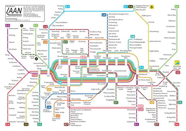
Deutsch: Planungsalternative "Südring" für die 2. Münchener S-Bahn-Stammstrecke
English: "Südring" planning variant for an additional rapid transit city crossing in Munich |
| Date | |
| Source | Own work |
| Author | Maximilian Dörrbecker (Chumwa) |
| Other versions |
Weitere Münchner ÖPNV-Pläne:
|


|
This transport map image could be re-created using vector graphics as an SVG file. This has several advantages; see Commons:Media for cleanup for more information. If an SVG form of this image is available, please upload it and afterwards replace this template with
{{vector version available|new image name}}.
It is recommended to name the SVG file “MuenchenSBahnMitSuedring.svg”—then the template Vector version available (or Vva) does not need the new image name parameter. |
Licensing
I, the copyright holder of this work, hereby publish it under the following license:
This file is licensed under the Creative Commons Attribution-Share Alike 2.5 Generic license.
- You are free:
- to share – to copy, distribute and transmit the work
- to remix – to adapt the work
- Under the following conditions:
- attribution – You must give appropriate credit, provide a link to the license, and indicate if changes were made. You may do so in any reasonable manner, but not in any way that suggests the licensor endorses you or your use.
- share alike – If you remix, transform, or build upon the material, you must distribute your contributions under the same or compatible license as the original.
File history
Click on a date/time to view the file as it appeared at that time.
| Date/Time | Thumbnail | Dimensions | User | Comment | |
|---|---|---|---|---|---|
| current | 20:36, 3 August 2011 | | 1,172 × 828 (212 KB) | Chumwa | Lage der Station Leienfelsstraße korrigiert |
| 17:29, 13 December 2009 |  | 1,172 × 828 (212 KB) | Chumwa | Anpassung an aktuelles Liniennetz | |
| 12:10, 20 August 2006 |  | 1,225 × 845 (281 KB) | Chumwa | Station Olympiapark Nord in Oberwiesenfelde umbenannt. | |
| 15:08, 5 February 2006 |  | 1,280 × 883 (296 KB) | Chumwa | *'''Description:''' München: Planungsalternative Südring für die 2. Stammstrecke *'''Source:''' M. Dörrbecker {{GFDL}} Category:ÖPNV "public transport" S-Bahn München Munich Category:public transport maps |
File usage
The following pages on the English Wikipedia use this file (pages on other projects are not listed):
Global file usage
The following other wikis use this file:
- Usage on de.wikipedia.org
- Usage on hu.wikipedia.org