
File:Mynydd Llandegai.jpg

Size of this preview: 800 × 575 pixels. Other resolutions: 320 × 230 pixels | 640 × 460 pixels | 1,024 × 736 pixels | 1,280 × 920 pixels | 1,530 × 1,100 pixels.
Original file (1,530 × 1,100 pixels, file size: 299 KB, MIME type: image/jpeg)
| This is a file from the Wikimedia Commons. Information from its description page there is shown below. Commons is a freely licensed media file repository. You can help. |
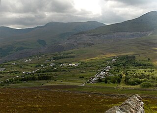
| Description | Mynydd Llandegai (Mynydd Llandygai), seen from the slopes of Moel y Ci. The mountains in the background are Carnedd Llywelyn (left-hand edge), Carnedd Dafydd, Pen yr Ole Wen and Elidir Fawr (right), with the Penrhyn Slate Quarry. |
| Date | |
| Source | Self-photographed |
| Author | Stemonitis |
| Camera location | | View this and other nearby images on: OpenStreetMap |
|---|
I, the copyright holder of this work, hereby publish it under the following license:
This file is licensed under the Creative Commons Attribution 2.5 Generic license.
- You are free:
- to share – to copy, distribute and transmit the work
- to remix – to adapt the work
- Under the following conditions:
- attribution – You must give appropriate credit, provide a link to the license, and indicate if changes were made. You may do so in any reasonable manner, but not in any way that suggests the licensor endorses you or your use.
File history
Click on a date/time to view the file as it appeared at that time.
| Date/Time | Thumbnail | Dimensions | User | Comment | |
|---|---|---|---|---|---|
| current | 12:21, 8 June 2007 | | 1,530 × 1,100 (299 KB) | Stemonitis | {{Information |Description=Mynydd Llandegai (Mynydd Llandygai), seen from the slopes of Moel y Ci. The mountains in the background are Carnedd Llywelyn (left-hand edge), Carnedd Dafydd, Pen yr Ole Wen and Elidir Fawr (right), with the Penr |
File usage
The following pages on the English Wikipedia use this file (pages on other projects are not listed):
Global file usage
The following other wikis use this file:
- Usage on br.wikipedia.org
- Usage on cy.wikipedia.org
- Usage on eu.wikipedia.org
- Usage on ga.wikipedia.org
- Usage on www.wikidata.org