
File:NO 0714 Hof.svg

Size of this PNG preview of this SVG file: 218 × 382 pixels. Other resolutions: 137 × 240 pixels | 274 × 480 pixels | 438 × 768 pixels | 584 × 1,024 pixels | 1,169 × 2,048 pixels.
Original file (SVG file, nominally 218 × 382 pixels, file size: 43 KB)
| This is a file from the Wikimedia Commons. Information from its description page there is shown below. Commons is a freely licensed media file repository. You can help. |
| Description |
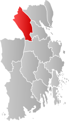
Norsk bokmål: Kart som viser Vestfolds plassering innen [[:no: {{{2}}}| {{{2}}}]], laga av Jon Harald Søby.
English: Map showing the position of Vestfold within [[:w: {{{2}}}| {{{2}}}]], made by Jon Harald Søby.
Svenska: Karta som visar Vestfold kommuns läge i [[:Category:{{{2}}}|{{{2}}}]] fylke, skapad av Jon Harald Søby.
This W3C-unspecified vector image was created with Inkscape . |
||
| Date | |||
| Source | Own work | ||
| Author | Jon Harald Søby | ||
| Permission (Reusing this file) |
|
File history
Click on a date/time to view the file as it appeared at that time.
| Date/Time | Thumbnail | Dimensions | User | Comment | |
|---|---|---|---|---|---|
| current | 20:45, 25 February 2024 | | 218 × 382 (43 KB) | Jay1279 | improve accuracy of borders |
| 10:19, 8 January 2017 |  | 449 × 786 (61 KB) | Bjarkan | Map of Hof. Borders updated for 2017. | |
| 17:43, 22 January 2007 |  | 449 × 786 (87 KB) | Jon Harald Søby | {{User:Jon Harald Søby/Kartlisens|Hof|Vestfold}} |
File usage
The following pages on the English Wikipedia use this file (pages on other projects are not listed):
Global file usage
The following other wikis use this file:
- Usage on ar.wikipedia.org
- Usage on bpy.wikipedia.org
- Usage on ca.wikipedia.org
- Usage on da.wikipedia.org
- Usage on de.wikipedia.org
- Usage on eo.wikipedia.org
- Usage on es.wikipedia.org
- Usage on eu.wikipedia.org
- Usage on fa.wikipedia.org
- Usage on fi.wikipedia.org
- Usage on fr.wikipedia.org
- Usage on hu.wikipedia.org
- Usage on hy.wikipedia.org
- Usage on it.wikipedia.org
- Usage on ka.wikipedia.org
- Usage on la.wikipedia.org
- Usage on li.wikipedia.org
- Usage on nds.wikipedia.org
- Usage on nl.wikipedia.org
- Usage on nn.wikipedia.org
- Usage on no.wikipedia.org
- Usage on pl.wikipedia.org
- Usage on pnb.wikipedia.org
- Usage on pt.wikipedia.org
- Usage on ro.wikipedia.org
- Usage on ru.wikipedia.org
- Usage on se.wikipedia.org
- Usage on sq.wikipedia.org
- Usage on sv.wikipedia.org
- Usage on th.wikipedia.org
- Usage on tr.wikipedia.org
- Usage on ur.wikipedia.org
- Usage on vi.wikipedia.org
- Usage on www.wikidata.org
- Usage on zh-min-nan.wikipedia.org