
File:NYSW Historical NJ and PA.svg

Original file (SVG file, nominally 800 × 600 pixels, file size: 675 KB)
| This is a file from the Wikimedia Commons. Information from its description page there is shown below. Commons is a freely licensed media file repository. You can help. |
Summary
| Description |
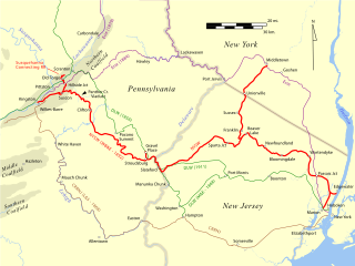
English: Map of the historical NYSW railroad through New Jersey and Pennsylvania. |
| Date | |
| Source | Own work |
| Author | JimIrwin |
The New York, Susquehanna and Western was one of four major railroads hauling anthracite coal from the Northern coalfield of Pennsylvania to the tidewater at New York City. The others were the Erie, the Central Railroad of New Jersey, and the Delaware, Lackawanna and Western.
Although the Lehigh Valley Railroad was a major anthracite coal railroad to the New York harbor, it primarily delivered coal from the Middle coalfield. Its route through the Scranton region was primarily for delivering freight into the Finger Lakes and Buffalo region. Likewise, the Reading railroad primarily delivered coal from the Southern coalfield. The Pennsylvania railroad was a less significant coal railroad, but its circuitous route to the New York harbor never favored it for coal.
The Delaware and Hudson was another competitor for coal from the Northern coalfield, but it had no direct route to tidewater.
Licensing
- You are free:
- to share – to copy, distribute and transmit the work
- to remix – to adapt the work
- Under the following conditions:
- attribution – You must give appropriate credit, provide a link to the license, and indicate if changes were made. You may do so in any reasonable manner, but not in any way that suggests the licensor endorses you or your use.
- share alike – If you remix, transform, or build upon the material, you must distribute your contributions under the same or compatible license as the original.

|
Permission is granted to copy, distribute and/or modify this document under the terms of the GNU Free Documentation License, Version 1.2 or any later version published by the Free Software Foundation; with no Invariant Sections, no Front-Cover Texts, and no Back-Cover Texts. A copy of the license is included in the section entitled GNU Free Documentation License. |
File history
Click on a date/time to view the file as it appeared at that time.
| Date/Time | Thumbnail | Dimensions | User | Comment | |
|---|---|---|---|---|---|
| current | 16:08, 27 September 2009 | | 800 × 600 (675 KB) | JimIrwin | {{Information |Description={{en|1=Map of the historical NYSW railroad through New Jersey and Pennsylvania.}} |Source=Own work by uploader |Author=JimIrwin |Date=2009-09-27 |Permission= |other_versions= }} |
File usage
Global file usage
The following other wikis use this file:
- Usage on sv.wikipedia.org
- Usage on www.wikidata.org