
File:Nachalat Shiv'a's Map2.JPG
No higher resolution available.
Nachalat_Shiv'a's_Map2.JPG (195 × 334 pixels, file size: 12 KB, MIME type: image/jpeg)
| This is a file from the Wikimedia Commons. Information from its description page there is shown below. Commons is a freely licensed media file repository. You can help. |
Summary
| Description |
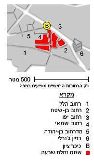
English: Map of Nachalat Shiv'a Neighborhood, Jerusalem :
1 Hillel Street 2 Ben Shetach Street 3 Yafo Street 4 Shamai Street 5 Ben Yehuda Pedestrian Street 6 Generali building B Tzion Square |
| Date | |
| Source | Modification of the free Hebrew Wikipedia Map Jaffo draw.jpg |
| Author | דובב, Hebrew Wikipedia (modification by Eddau) |
Licensing
| This file is made available under the Creative Commons CC0 1.0 Universal Public Domain Dedication. | |
| The person who associated a work with this deed has dedicated the work to the public domain by waiving all of their rights to the work worldwide under copyright law, including all related and neighboring rights, to the extent allowed by law. You can copy, modify, distribute and perform the work, even for commercial purposes, all without asking permission.
|
File history
Click on a date/time to view the file as it appeared at that time.
| Date/Time | Thumbnail | Dimensions | User | Comment | |
|---|---|---|---|---|---|
| current | 11:02, 20 July 2009 | | 195 × 334 (12 KB) | Eddau~commonswiki | {{Information |Description=Map of Nachalat Shiv'a Neighborhood, Jerusalem |Source=Modification of the free Hebrew Wikipedia Map Jaffo draw.jpg |Date=2009 Jul 20 |Author= דובב, Hebrew Wikipedia (modification by Eddau) |Permission=free |other_versions= |
File usage
The following pages on the English Wikipedia use this file (pages on other projects are not listed):
Global file usage
The following other wikis use this file:
- Usage on uk.wikipedia.org
- Usage on zh.wikipedia.org