
File:Nahant-Rd-FCT-View-S.jpg

Original file (2,000 × 927 pixels, file size: 499 KB, MIME type: image/jpeg)
| This is a file from the Wikimedia Commons. Information from its description page there is shown below. Commons is a freely licensed media file repository. You can help. |
Summary
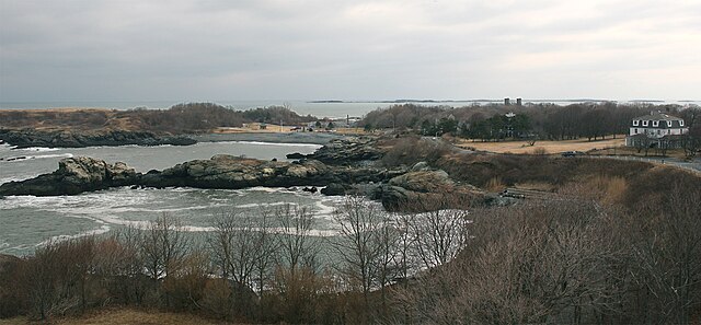
This photo, taken on an overcast day in February, 2010, looks south from the top observation level of the Nahant Road fire control tower (about 100 ft. above sea level). Brightness and contrast have been adjusted to make distant islands/shores more easily visible.
The island just left of center is Outer Brewster Island, about 6 mi. distant. Beyond that are the shores of Hull, MA, the boundary of the southern approaches to Boston Harbor. The two square towers at right-center are the Swallow Cave Rd. fire control towers.
The small building with the peaked roof in the brown field at center-left is the structure marked "Stone House" on the area plan of the East Point Batteries. One of the west side truck entries to Battery Murphy is just left of that building, obscured by the trees.
Battery 206 is on the other side of the small hill beyond the Stone House and just to its right. The "hill" is in fact the earthen cover of the Battery 206 central magazine, viewed from behind.
The two 16-inch guns of Battery Murphy face the sea beyond the partially wooded ridge at left center of the photo. The tree-covered hillock between the Stone House and the twin fire control towers is the earthen-covered plotting room for Battery Murphy, which is entered from the rear, off of Swallow Cave Rd.
Licensing
- You are free:
- to share – to copy, distribute and transmit the work
- to remix – to adapt the work
- Under the following conditions:
- attribution – You must give appropriate credit, provide a link to the license, and indicate if changes were made. You may do so in any reasonable manner, but not in any way that suggests the licensor endorses you or your use.
- share alike – If you remix, transform, or build upon the material, you must distribute your contributions under the same or compatible license as the original.
File history
Click on a date/time to view the file as it appeared at that time.
| Date/Time | Thumbnail | Dimensions | User | Comment | |
|---|---|---|---|---|---|
| current | 15:00, 22 September 2010 | | 2,000 × 927 (499 KB) | Pgrig | This photo, taken on an overcast day in February, 2010, looks south from the top observation level of the Nahant Road fire control tower. The island just left of center is Outer Brewster Island, about 6 mi. distant. Beyond that are the shores of Hull, MA |